Many people expect that after the Red River urban planning scheme is approved, it will be a great opportunity for Hanoi to solve the problem of green space shortage.
There is great potential for exploitation.
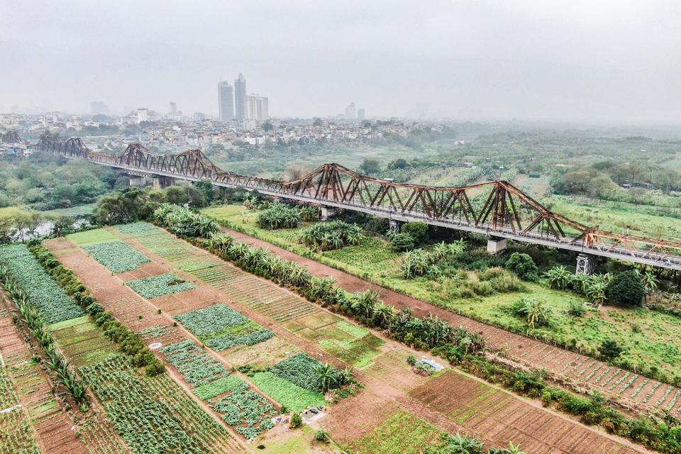
According to statistics, the Red River floodplain (the mid-river sandbank) alone covers a relatively large area of approximately 329 hectares, spanning across four districts: Hoan Kiem, Ba Dinh, Tay Ho, and Long Bien. However, the reality is that much of this barren land remains undeveloped; violations of dike regulations are occurring; and leased land is being used for spontaneous production, failing to meet requirements regarding landscape and environmental hygiene.
Furthermore, a large portion of the alluvial plain lies within the border area between districts, making boundary demarcation on the ground difficult. Land and construction management in this area has not received sufficient attention, and the lack of a unified management approach has led to violations of land use and construction regulations.
According to Architect Nguyen Toan Thang, Head of the Urban Management Department of Hoan Kiem District, in addition to the aforementioned shortcomings, the question of how to maximize the value of the space and landscape of the Red River floodplain has long been raised by various levels and sectors. However, in previous years, this issue faced legal obstacles, especially regulations under the Law on Dikes. With the approval of the Red River Urban Planning by the Hanoi People's Committee, very favorable conditions have been created to develop the Red River into an important urban landscape axis of the capital, especially the floodplain area, aiming to create green spaces right in the heart of the city.
According to Mr. Nguyen Toan Thang, the most important alluvial area in the middle of the Red River is located below the Long Bien Bridge, mainly within the administrative boundaries of Hoan Kiem District, and is a large green space of about 23 hectares. In recent years, the water level of the Red River rarely rises high, and the area of the alluvial plain has changed little.
Meanwhile, upstream on the Red River, the construction of large and small hydroelectric dams has reduced the frequency and intensity of floods compared to the past. Therefore, even during the rainy season, the alluvial plains in the middle of the Red River become fertile fields with crops of all seasons, and also serve as a spontaneous recreational spot for many Hanoi residents. This confirms the significant potential and ample opportunities for development of the Red River's alluvial plains.
“The area in the middle of the Red River is a precious piece of land bestowed upon Hanoi by nature. It is also the only remaining space in Hoan Kiem district, along with three other districts – Ba Dinh, Tay Ho, and Long Bien – that can be used to create an attractive green, ecological public space,” said Mr. Nguyen Toan Thang.
The people agree and support it.
According to Mr. Nguyen Toan Thang, Hoan Kiem district, in coordination with Ba Dinh, Tay Ho, and Long Bien districts, is gradually developing plans and projects aimed at effectively exploiting the land in the middle of the Red River to match its position in the area, efficiently utilizing the land and potential advantages, improving the landscape, developing socio-economic aspects, and ensuring national security and defense. This will concretize the spatial organization of the Red River urban planning zone approved by the Hanoi People's Committee.
The focus will be on strengthening the development of green models: parks, themed green spaces - high-quality and technically advanced urban agriculture , agricultural tourism, etc., attracting green economic activities, night-time economy, tourism economy, and sports (services, tourism, sports, etc.) in line with the socio-economic development orientation of each locality.
Creating green spaces: urban parks, themed parks, and floodplain parks based on exploiting the landscape on both sides of the Red River, in accordance with natural conditions, topographic terraces, and current land use. The riverbank and river areas are mostly unstable, suitable for ecological spaces and natural restoration.
In some areas adjacent to the historical inner city, embankments are planned to create conditions for organizing cultural public spaces adjacent to the water. In addition, the solution involves organizing green spaces, water features, and urban amenities based on the principles of natural restoration, natural parks, urban parks, and integrated public spaces. A portion of agricultural space will be organized into parks, agricultural areas, and urban agriculture combined with tourism and outdoor activities, enhancing the efficiency of land use…
Ms. Tran Thi Thanh, residing at house number 24, alley 43 Bach Dang, Chuong Duong ward, stated that the authorities' plan to develop a master plan and project to transform the entire area of the Red River's sandbank into an urban park and green ecological park has received the approval and support of many residents. She added that the residents are very happy and excited that the implementation of the plan and project will significantly change the urban landscape of this area.
For many years, the Chương Dương ward, especially the area near the eroded bank of the Red River, has been characterized by densely populated residential areas with many narrow alleys and cramped houses. In particular, along the eroded bank are sewage pipes directly discharging into the Red River, compounded by the lack of awareness among some residents who carelessly litter and burn garbage.
Along with the construction of more hydroelectric dams upstream, this has caused stagnant water with poor circulation in the area between the riverbanks and the sandbar in Hoan Kiem district, leading to foul odors. This pollution problem is mitigated during the rainy season when the river washes away accumulated garbage and wastewater.
Expressing her desire for the planning and implementation of the project, Ms. Do Thi Kim Anh, Deputy Secretary of the Party branch and Head of the Front Committee of Bach Dang residential area, Chuong Duong ward, shared that the issue of planning and developing the Red River mid-river area into a green park and ecological park is extremely necessary. Besides maximizing the potential and advantages of the mid-river area, it also helps to transform existing urban aesthetics and environmental sanitation issues in the riverbank area.


Ms. Anh added that, besides waiting for the planning and implementation of the project, the people in Bach Dang residential area have also continuously responded to the call for a green and sustainable development by Hoan Kiem district, organizing environmental cleanup campaigns, clearing bushes, and collecting accumulated waste. This has resulted in a clean and beautiful street with green spaces, many types of flowers, and a green area for residents to visit, enjoy recreation, and exercise to improve their health.
The immediate priority is to develop a plan and project aimed at effectively utilizing the land resources and potential advantages, as well as the inherent natural beauty of the Red River, using the Red River as a landscape axis to create open, green spaces with civilized and modern urban infrastructure. Simultaneously, it should become a highly attractive destination, allowing the community and tourists to experience one of Hanoi's unique open spaces, overlooking the river and oriented towards a green ecological park on the water.
Architect Nguyen Toan Thang - Head of Urban Management Department, Hoan Kiem District
Source: https://kinhtedothi.vn/ky-vong-bai-giua-song-hong-thanh-khong-gian-xanh.html