
(QBĐT) - Running along the length of Quang Binh province, the national highway is associated with the history of development and expansion of the territory, expressing the aspiration to unify the country.
True to its name, the Thousand-mile Road, or Thousand-mile Road, is the road that connects the regions of the country from North to South. Starting from the Northern Delta, according to the historical process of the nation, the Thousand-mile Road was gradually extended to the southernmost part of the country, and the section passing through Quang Binh province has a history of over 10 centuries.
Mile of history
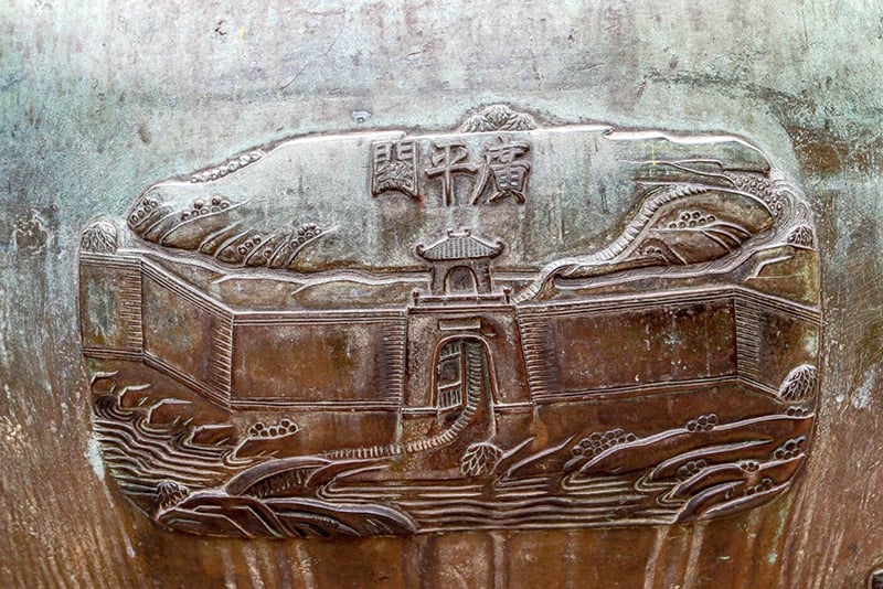
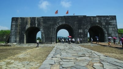
Starting from the northernmost point of the province at the southern ridge of Hoanh Son range, in the territory of Quang Dong commune (Quang Trach), connected with the Hoanh Son Quan relic, bordering Ha Tinh province, the national highway runs along the coast to the southernmost point in the territory of Sen Binh, Sen Thuy, Le Thuy villages, bordering Quang Tri province. During the Tien Le period, in 992, King Le Dai Hanh ordered troops to build a road from Ha Tinh to Dia Ly district. "In the autumn, in the 8th month, he ordered the king Ngo Tu An to bring 30,000 people to open a road from Nam Gioi seaport to Dia Ly district" (1). This is considered the first milestone, marking the process of opening the national highway through Quang Binh. In 1402, Ho Quy Ly mobilized a large number of soldiers and laborers to open the national highway from Hoan Chau (Nghe An) to Hoa Chau (Hue).
Since gaining independence, the Tien Le, Dinh, Ly, Tran, Le dynasties... have paid attention to expanding the national highway to facilitate trade, connection between regions as well as expanding the territory. Because the national highway was mainly for use by mandarins, it was also called the mandarin's main road. In 1776, when writing Phu Bien Tap Luc, Le Quy Don described the national highway through Quang Binh very briefly, only giving the direction and the scenery on both sides of the road. "From Nghe An, go south, cross Hoanh Son mountain, through Thuan Than, Phu Luu communes, Bo Chinh district, go east to Lu Dang commune, then reach Gianh river" (2).
 |
After ascending the throne in 1801, along with the consolidation of the road system along the royal route, King Gia Long ordered the construction and repair of the mandarin road from the capital Phu Xuan to Dong Hai (now Dong Hai ward, Dong Hoi city). “Repairing the mandarin road from Phu Xuan to Dong Hai” (3). In 1802, King Gia Long ordered the Minister of Infantry Le Quang Dinh to compile books and maps of the whole country, the citadels and towns from Kinh Su to the South to Ha Tien, to the North to Lang Son, and write them into the book Hoang Viet Nhat Thong Du Dia Chi. The road from Quang Binh citadel to the places in the citadels and towns was listed in the book Hoang Viet Nhat Thong Du Dia Chi in great detail. Also in this year, King Gia Long ordered the repair of roads and bridges. “Ordered the localities of Quang Duc, Quang Tri, Quang Binh to repair the palaces and roads and bridges” (4).
In the 9th year of Gia Long (1810), the court continued to repair bridges and culverts, straightening out the curved roads . "Repair bridges and roads in Quang Duc, Quang Tri, and Quang Binh. The King saw that the old roads were winding and muddy, so he ordered the Inspector Tran Van Hoc to measure the terrain, get people to repair them, and provide daily rations. Also, seeing that the summer weather was hot, he warned them not to push too hard, to loosen the people's strength" (5). One month later, he ordered the Ly Hoa bridge to be repaired . "Rebuild the Ly Hoa bridge in Quang Binh (The old bridge had 138 spans, now the river is 74 truong wide, so we rebuilt 56 spans, reducing the old by 82 spans), and the Cao Cong Giang commanding officer oversaw the work" (6).
During the first half of the 19th century, Nguyen Dynasty kings such as Thieu Tri, Tu Duc... all paid great attention to consolidating, upgrading and completing the royal road. In 1847, King Tu Duc approved the report that "The Ministry of Public Works is planning the assignment. Therefore, along the road from Thua Thien back to the North to Hanoi, the bridges and roads that the Qing Dynasty envoys will leave behind will all be inspected by the local authorities until February of this year, when there is no public work, to verify the authenticity. Any damaged areas will be repaired, any broken areas will be filled up, so that they are all durable..." (7).
In which, Quang Binh province has "5 bridges, 168 stone culverts, water culverts, 4 ferries, from the beginning of the border through Quang Loc, Quang Xa to the provincial city. Then through Quang Ninh, Quang Cao, Quang Khe, Quang Yen to Hoanh Son province (the top is more correct - NV), the end of the border borders Ha Tinh province, including 6 stations" (8). Recognizing the role and importance of the vital traffic route, the Nguyen Dynasty emperors paid great attention to building, consolidating, and expanding, so the royal road was gradually completed. In the section on Roads of Quang Binh province, the book Dai Nam Nhat Thong Chi also describes this road very briefly "An important road, in the South bordering the beginning of Tri Lap station in Quang Tri province, in the North to Hoanh Son pass bordering the beginning of Tinh Than station in Ha Tinh province, 195 miles long" (9).
The main road
After invading our country, in order to carry out the colonial exploitation program, the French colonialists began to build and upgrade the transportation system. Governor-General of Indochina Paul Doumer (term 1897-1902) initiated the implementation of this program, including the construction of a railway, road and waterway transportation system. In his memoir “Indochina”, Governor-General of Indochina Paul Doumer describes the royal road section through Quang Binh province : “The main road passes through a pass right on the coast and then crosses the mountain ranges and continues continuously. It is the most uncomfortable section of the whole road. In addition to the stone steps that must be climbed to go up and down the pass, there is also a long stretch of quicksand, where the horse's feet are knee-deep in sand. … We crossed the mountain area that the Annamese call Ngang Pass” (10).
In 1912, Governor-General of Indochina Albert Sarraut (1872-1962) signed a decision to build a road network throughout Indochina. During his second term, on June 18, 1918, this Governor-General continued to issue a decree classifying the main roads in Indochina and naming them as colonial roads, provincial roads, and infiltration roads, while rural roads were called communal roads. Colonial roads became the main axis of the road traffic system in Vietnam in particular and Indochina in general. “As for “Colonial Road No. 1” passing through Quang Binh, the French mainly relied on the previous imperial road, surveyed and redesigned it, and in 1911 completed the survey on the map” (11). The Indochina budget funded the construction and maintenance of this route. According to the decree dated June 18, 1918, Indochina had 18 colonial roads, the most important of which was Colonial Road No. 1 (Route Coloniale N01), commonly known as Route No. 1.
This road runs from the Chinese border to the Thai border, connecting the capitals of the provinces of Tonkin, Annam, Cochinchina and Cambodia. It was reinforced by the French colonialists, and was graded with compacted clay according to the standards of a grade 5 plain road. The sections of the road through Ngang Pass and Ly Hoa Pass were rerouted along the mountainside, lowering the slope to make it easier for cars to go up and down. Small rivers were built with narrow-gauge rigid bridges, just enough for one lane, such as Cau Roon and Ly Hoa bridges. Particularly, the Nhat Le and Gianh rivers had to use 12-ton ferries to transport vehicles across the river, but there were no canoes, and each ferry had 8 sailors rowing by hand.
In 1913, this route began to be repaired and renovated continuously. By January 1, 1930, the renovation was completed with a total cost of up to 19 million Indochinese piastres. At this time, the road surface was widened, many bridges and culverts were built to make travel easier and more convenient.
Colonial Road No. 1 is the successor to the existing trans-Vietnam highways, which later became National Highway 1. It is a special road that represents the aspiration for national unification, and the section through Quang Binh is a shining expression of that noble aspiration.
Nhat Linh
(1). Ngo Si Lien, Complete Annals of Dai Viet, Hong Duc Publishing House, Hanoi, 2022, p.177.
(2) Le Quy Don, Phu Bien Tap Luc, Da Nang Publishing House, Da Nang, 2015, p.83.
(3), (4), (5), (6), National History Institute of Nguyen Dynasty, Dai Nam Thuc Luc, Hanoi Publishing House, Hanoi, 2022, volume 1, pp.459, 497, 786, 788.
(7), (8) Nguyen Dynasty Cabinet, Imperial Code of Dai Nam, Thuan Hoa Publishing House, Hue, 2005, volume 7, p.326.
(9) National History Institute of Nguyen Dynasty, Dai Nam Nhat Thong Chi, Labor Publishing House, 2012, volume 1, p.528.
(10) Paul Doumer, Indochina, The Gioi Publishing House, Hanoi, 2019, p.371.
(11) Quang Binh Department of Transport, History of Quang Binh Transport (1945-2015), Transport Publishing House, Hanoi, 2015, p.47.
Source: https://www.baoquangbinh.vn/van-hoa/202504/duong-thien-ly-tren-dat-quang-binh-2225585/


![[Photo] Fireworks light up the sky of Ho Chi Minh City 50 years after Liberation Day](https://vphoto.vietnam.vn/thumb/1200x675/vietnam/resource/IMAGE/2025/4/30/8efd6e5cb4e147b4897305b65eb00c6f)

![[Photo] Feast your eyes on images of parades and marching groups seen from above](https://vphoto.vietnam.vn/thumb/1200x675/vietnam/resource/IMAGE/2025/4/30/3525302266124e69819126aa93c41092)


Comment (0)