


Illustrative photo. (Source: VNA)
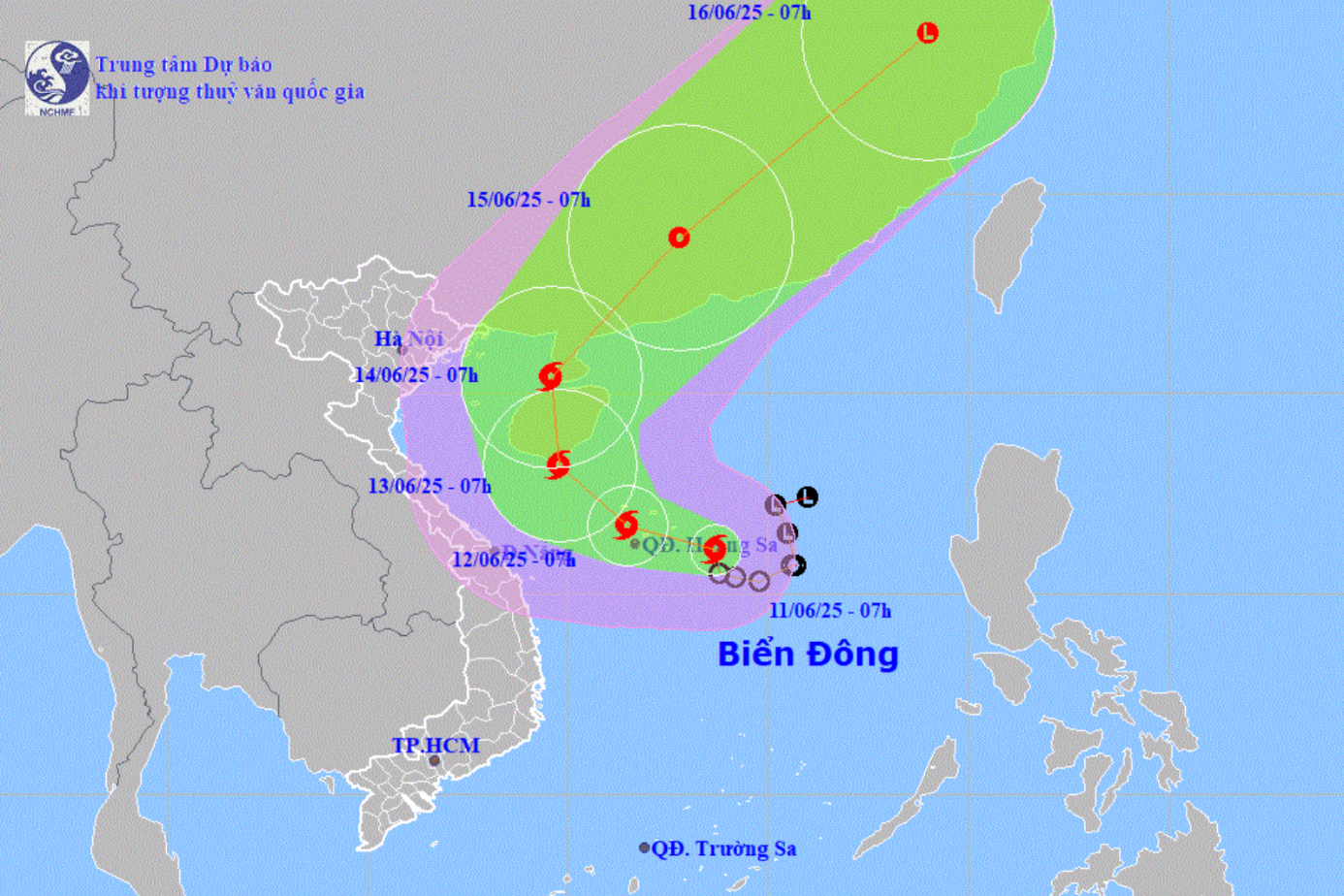
According to the National Center for Hydro-Meteorological Forecasting, a low pressure area is currently active in the eastern region of the Philippines.
At 1 p.m., the center of the low pressure area was at about 14.5-15.5 degrees North latitude; 126.5-127.5 degrees East longitude, in the sea east of the Philippines.
It is forecasted that in the next 24-36 hours, the low pressure area will move in a West-Northwest direction, traveling 15-20km per hour, into the East Sea and is likely to strengthen into a tropical depression.
Head of the Weather Forecast Department, National Center for Hydro-Meteorological Forecasting Nguyen Van Huong said that after forming, the tropical depression is likely to continue to strengthen into a storm with a probability of 60-70%, moving quickly towards the Gulf of Tonkin in the next 2-3 days.
Due to the influence of the low pressure circulation, later a tropical depression that is likely to strengthen into a storm, in the coming days, the northern and central areas of the East Sea (including the Hoang Sa special zone) and the Gulf of Tonkin will have increasingly strong winds and bad weather; ships operating in these sea areas need to take proactive precautions to ensure safety.
In addition, from August 25, in the North and the area from Thanh Hoa to Hue, there is a possibility of widespread moderate to heavy rain.
"The situation may still be complicated, so we recommend regularly monitoring and updating information through official bulletins of hydrometeorological agencies on mass media," Mr. Nguyen Van Huong noted./.
According to Vietnamplus
Source: https://www.vietnamplus.vn/xuat-hien-vung-ap-thap-hoat-dong-o-khu-vuc-phia-dong-philippines-post1057069.vnp
Source: https://baolongan.vn/xuat-hien-vung-ap-thap-hoat-dong-o-khu-vuc-phia-dong-philippines-a201126.html


![[Photo] An Phu intersection project connecting Ho Chi Minh City-Long Thanh-Dau Giay expressway behind schedule](https://vstatic.vietnam.vn/vietnam/resource/IMAGE/2025/8/21/1ad80e9dd8944150bb72e6c49ecc7e08)


![[Photo] Politburo works with the Standing Committee of Hanoi Party Committee and Ho Chi Minh City Party Committee](https://vstatic.vietnam.vn/vietnam/resource/IMAGE/2025/8/21/4f3460337a6045e7847d50d38704355d)


Comment (0)