

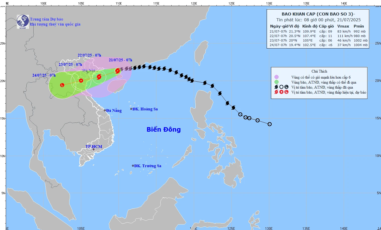
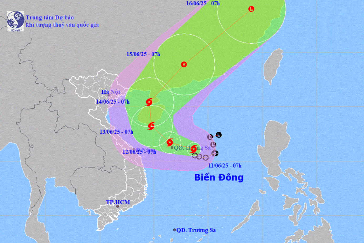
Path of storm number 3 released at 8:00 a.m. on July 21, 2025.
At 7:00 a.m. on July 21, the storm center was at about 21.3 degrees North latitude; 109.9 degrees East longitude, in the northern area of Leizhou Peninsula (China), about 220km East of Quang Ninh - Hai Phong . The strongest wind was level 9 (75-88km/h), gusting to level 11. The storm moved West Southwest at a speed of 15-20km/h.
Storm forecast (next 24 to 72 hours) as follows:
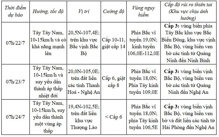
Due to the influence of the storm, the Northwest of the North East Sea has winds of level 7-8, gusting to level 10; waves 3-5m high, rough seas.
Northern Gulf of Tonkin, wind level 6-7, increasing to level 8-9, near the storm center level 10-11, gust level 14; waves 3-5m high, rough seas.
Southern Bac Bo Gulf wind level 6-7, near the storm center level 8-9, gust level 11; waves 2-4m high, very rough seas.
The coastal areas of Hung Yen - Quang Ninh have storm surges of 0.5-1.0m high. The water level at Hon Dau (Hai Phong) is 3.7-4.1m high, at Cua Ong (Quang Ninh) is 4.4-4.8m high and at Tra Co (Quang Ninh) is 3.6-4m high. There is a high risk of flooding in coastal areas and river mouths on the afternoon of July 22.
The meteorological agency warns that the sea is extremely dangerous and unsafe for all types of boats, aquaculture rafts, and coastal structures. There is a risk of capsizing, destruction, and flooding due to strong winds, big waves, and rising sea levels.
On land, from tonight and tonight, the coastal areas of Quang Ninh - Nghe An will have strong winds of level 7-9, near the storm center level 10-11, gusting to level 14; deep inland level 6, gusting to level 7-8. Winds of level 10-11 can cause trees, electric poles, and roofs to fall, causing great damage.
From July 21-23, the Northeast, Northern Delta, Thanh Hoa, Nghe An will have 200-350mm of rain, with some places having over 600mm. Other places in the North and Ha Tinh will have 100-200mm of rain, with some places having over 300mm.
Warning of heavy rain over 150mm/3h, high risk of flash floods, landslides in mountainous areas, deep flooding in low-lying areas.
NDS
Source: https://baothanhhoa.vn/bao-so-3-cach-quang-ninh-hai-phong-khoang-220km-giat-cap-11-255498.htm


![[Photo] New look of the coastal city on the Han River](https://vstatic.vietnam.vn/vietnam/resource/IMAGE/2025/8/22/26f58a4a29b9407aa5722647f119b498)


Comment (0)