

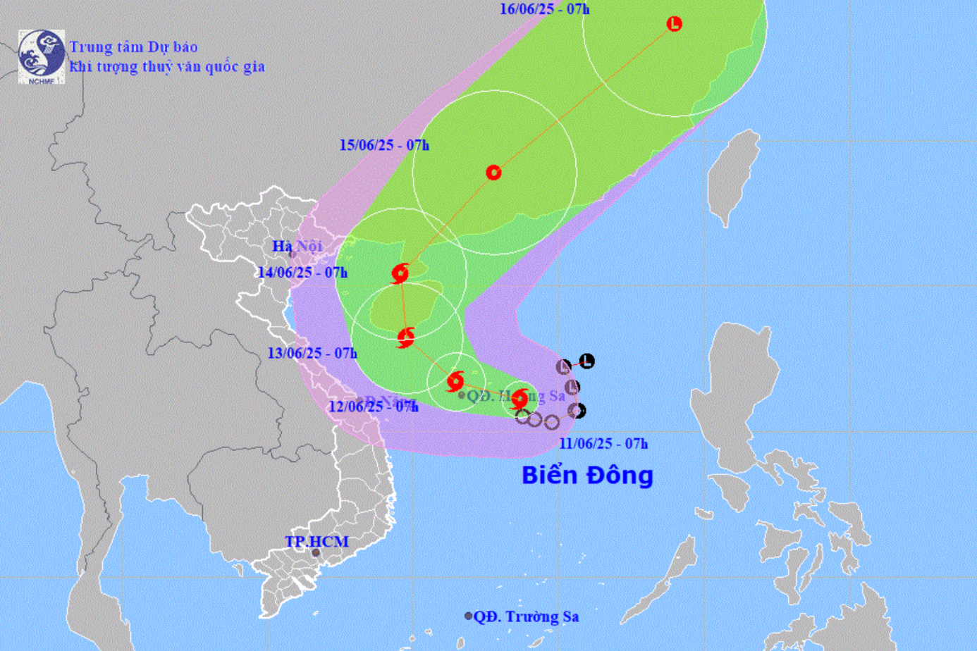
At 4:00 a.m. this morning, the storm center was at about 21.3 degrees North latitude; 117.9 degrees East longitude, in the northeastern area of the East Sea. The strongest wind near the storm center reached level 10 (89–102 km/h), gusting to level 12. The storm moved slowly north at a speed of about 5 km/h.
In the next 24 hours, the storm is forecast to move in a North-Northeast direction at a speed of 15-20 km/h and is likely to strengthen. At 4:00 a.m. on July 7, the center of the storm was determined to be at approximately 24.4 degrees North latitude; 119.7 degrees East longitude, located in the sea of Fujian province (China), with strong winds of level 10-11, gusting to level 13. The dangerous area is determined to be north of latitude 19.5 degrees North; east of longitude 116.5 degrees East. Level 3 natural disaster risk applies to the northeastern area of the East Sea.
On July 8, the storm continued to move in a north-northeast direction, maintaining a speed of 15-20 km/h, entering the sea area of Zhejiang province (China). By the morning of July 9, the storm turned west-northwest with a slower speed (5-10 km/h), entering the mainland of Zhejiang province and gradually weakening into a low pressure area, with the intensity decreasing to below level 6.

Due to the influence of storm No. 2, in the northeastern sea area of the North East Sea, there is currently stormy rain, strong winds of level 7-9, the area near the storm's center reaches level 10-11, gusts of level 13. Waves are 4-6m high, the sea is very rough. The southeastern area of the North East Sea is also affected, strong winds of level 6, gusts of level 7-8, waves 2-4m high.
The area between the East Sea and the sea from Khanh Hoa to Ca Mau recorded wind level 5, sometimes level 6, gusting to level 7-8, rough sea.
The North East Sea, the Northeast between the East Sea (including the Hoang Sa sea area) and the Gulf of Thailand will have showers and thunderstorms. In particular, the Northeast of the North East Sea will have strong storms. During thunderstorms, there is a high possibility of tornadoes and strong gusts of wind.
From the day and night of July 7, the northeastern sea area of the North East Sea will continue to have strong winds of level 7-8, near the storm center level 9-10, gusts of level 12, waves from 3-5 m high, very rough seas. Ships operating in these areas are at high risk of being affected by tornadoes, strong winds and large waves. Disaster risk level 2. In particular, the northeastern sea area of the North East Sea - where the storm is likely to cause the most serious impact - level 3.
Coastal localities and authorities need to closely monitor the storm's developments, maintain regular contact with vessels operating at sea, and be ready to deploy safety measures to avoid damage caused by strong winds and large waves.
Weather forecast for regions across the country:
Hanoi capital is cloudy, sunny during the day; showers and thunderstorms in some places in the evening and at night. Light wind. Lowest temperature 25-27 degrees Celsius. Highest temperature 33-35 degrees Celsius.
The Northwestern region is cloudy, sunny during the day, hot in some places, scattered showers in the evening and at night and thunderstorms in some places. Light wind. During thunderstorms, there is a possibility of tornadoes, lightning, hail and strong gusts of wind. The lowest temperature is 24-27 degrees Celsius, in some places below 23 degrees Celsius. The highest temperature is 32-35 degrees Celsius, in some places above 35 degrees Celsius.
The northeastern provinces are cloudy, sunny during the day, hot in some places, showers and thunderstorms in some places in the evening and at night. Light wind. Lowest temperature 25-28 degrees Celsius. Highest temperature 32-35 degrees Celsius, some places above 35 degrees Celsius.
Provinces from Thanh Hoa to Hue will be cloudy with scattered showers and thunderstorms in some places, scattered showers and thunderstorms in the afternoon and at night, locally heavy rain in some places. Light wind. During thunderstorms, there is a possibility of tornadoes, lightning and strong gusts of wind. Lowest temperature 24-27 degrees Celsius. Highest temperature 31-34 degrees Celsius, some places above 34 degrees Celsius.
The South Central Coast region is cloudy, sunny during the day, hot in some places, showers and thunderstorms in the evening and at night in some places; in the North, there are scattered showers and thunderstorms in the afternoon and at night, locally heavy rain in some places. Southwest wind level 2-3. During thunderstorms, there is a possibility of tornadoes, lightning and strong gusts of wind. The lowest temperature is 25-28 degrees Celsius. The highest temperature is 32-35 degrees Celsius, some places are over 35 degrees Celsius.
The Central Highlands is cloudy with scattered showers and thunderstorms, with scattered showers and thunderstorms in the late afternoon and evening, with some heavy rain in some places. Southwesterly winds at level 2-3. There is a possibility of tornadoes, lightning and strong gusts of wind during thunderstorms. The lowest temperature is 20-23 degrees Celsius. The highest temperature is 27-30 degrees Celsius, with some places above 30 degrees Celsius.
The South is cloudy with scattered showers and thunderstorms, with scattered showers and thunderstorms in the late afternoon and evening, with some heavy rain in some places. Southwesterly winds level 2-3. There is a possibility of tornadoes, lightning and strong gusts of wind during thunderstorms. Lowest temperature 24-27 degrees Celsius. Highest temperature 31-34 degrees Celsius, with some places above 34 degrees Celsius.
Ho Chi Minh City is cloudy, sunny during the day, scattered showers and thunderstorms in the late afternoon and evening, and showers and thunderstorms in some places at night. Southwest wind level 2-3. During thunderstorms, there is a possibility of tornadoes, lightning and strong gusts of wind. Lowest temperature 24-26 degrees Celsius. Highest temperature 32-34 degrees Celsius.
Source: https://www.sggp.org.vn/bao-so-2-tren-bien-dong-di-chuyen-cham-bien-dong-du-doi-post802647.html


![[Photo] An Phu intersection project connecting Ho Chi Minh City-Long Thanh-Dau Giay expressway behind schedule](https://vstatic.vietnam.vn/vietnam/resource/IMAGE/2025/8/21/1ad80e9dd8944150bb72e6c49ecc7e08)


![[Photo] Politburo works with the Standing Committee of Hanoi Party Committee and Ho Chi Minh City Party Committee](https://vstatic.vietnam.vn/vietnam/resource/IMAGE/2025/8/21/4f3460337a6045e7847d50d38704355d)


Comment (0)