

Pursuant to Directive No. 22/CT-TTg dated July 23, 2024 of the Prime Minister on land inventory in 2024; Decision No. 817/QD-TTg dated August 9, 2024 of the Prime Minister approving the project "Land inventory and development of land use status map in 2024"; Circular No. 8/2024/TTBTNMT dated July 31, 2024 of the Minister of Natural Resources and Environment regulating land statistics, land inventory and development of land use status map, Quang Tri province develops a plan for land inventory and development of land use status map in 2024.
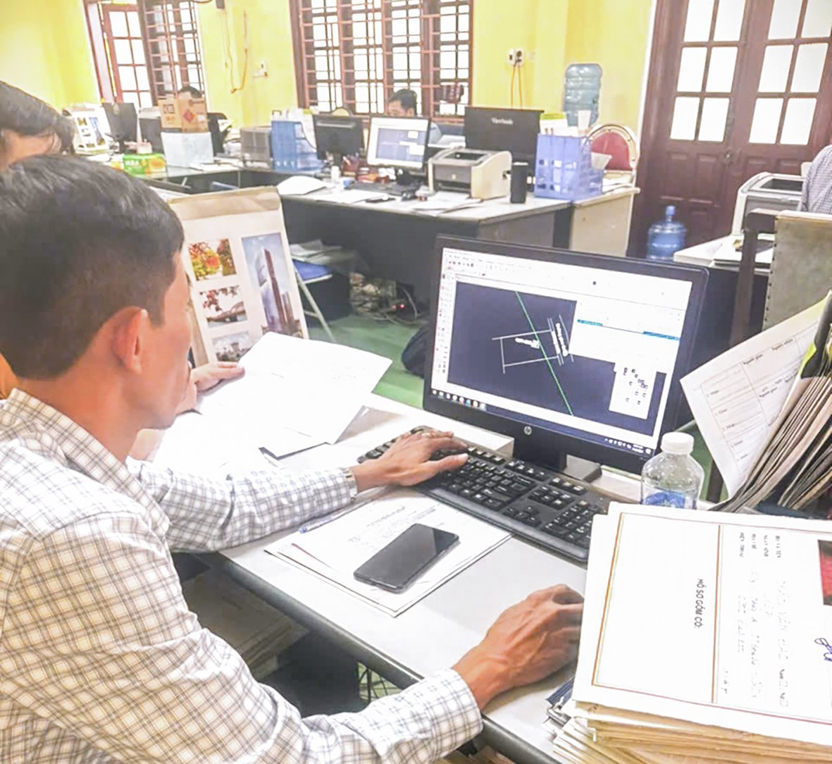
Staff of the Dong Ha City Land Registration Office Branch create a land plot map to serve the work of granting land use right certificates - Photo: TN
The purpose of the 2024 land inventory is to assess the current status of land management and use of each administrative unit at the commune, district and provincial levels; assess the land management and use situation at all levels in the past 5 years and propose mechanisms, policies and measures to strengthen state management of land and improve land use efficiency. Provide aggregated data, report national statistical indicators, serve the land information needs for socio -economic activities, national defense and security, scientific research, as a basis for adjusting land use planning and plans for the period 2021-2030, with a vision to 2045.
According to the plan of the Provincial Land Inventory Steering Committee in 2024, land inventory and mapping of current land use status in 2024 will be carried out throughout the province, in which the commune level is the basic unit to conduct the inventory and is also the basis for synthesizing the results of land inventory and mapping of current land use status of the district and provincial levels.
In addition, the 2024 land inventory must be carried out in accordance with the provisions of Article 9 on land classification of the 2024 Land Law. At the same time, during this land inventory, an assessment will be made of the management and use of golf course land; airports; landslide and alluvial areas; land originating from agricultural and forestry farms and other topics in localities as a basis for implementing measures to strengthen management and improve land use efficiency for these types of land.
The content of the 2024 land inventory is carried out for each administrative unit at all levels, determining the area of land types; the area of land users and land managers according to the provisions of the 2024 Land Law and creating a map of the current land use status in 2024.
In particular, focus on thematic land inventories for some types of golf course land; airport land; land in landslide and alluvial areas; land originating from agricultural and forestry farms and other topics. The results of the 2024 land inventory must fully collect land inventory data at all levels, thematic land inventory data; maps of current land use at all levels; reports on results of land inventories at all levels; reports on thematic land inventory.
The 2024 land inventory is conducted on the basis of existing land documents and data, combined with field investigations, delineation, and mapping of land changes during the land inventory period (from 2020 to the end of 2024); the results of the 2024 land inventory are synthesized according to regulations and shown on the current land use map; thematic land inventory is conducted using direct investigation methods and other relevant methods for synthesis and reporting.
Apply information technology to calculate and synthesize land areas, and create maps of current land use at all levels to ensure accuracy and consistency in land inventory results. Strengthen inspection and close supervision during the implementation process; pay special attention to checking and accepting the implementation results of all stages at all levels, especially at the commune level, to ensure the quality requirements and honesty of land inventory data in 2024.
Therefore, the Provincial Steering Committee for Land Inventory 2024 requests the Department of Home Affairs to provide natural area data and administrative boundary maps (in digital form) to the Department of Natural Resources and Environment to ensure consistency in natural area data of administrative units in the province. The Department of Agriculture and Rural Development coordinates with the Department of Natural Resources and Environment and the District People's Committees to direct forest management boards, conservation areas, national parks and agricultural and forestry companies to review and declare the current status of land use and provide land information and documents to serve the requirements of land inventory and mapping of current land use in 2024.
Provide maps (in digital form), survey results, forest status inventory and statistics of the most recent year's forest status; approval documents for planning of 3 types of forests and other specialized planning to the Department of Natural Resources and Environment, District People's Committees; review forest inventory data, forest status statistics in the province to unify forestry land inventory data in 2024.
On the other hand, agricultural and forestry companies such as Quang Tri Rubber One Member Co., Ltd., Ben Hai Forestry One Member Co., Ltd., Duong 9 Forestry One Member Co., Ltd., Trieu Hai Forestry One Member Co., Ltd. coordinate with the locality where the land is used and the Department of Natural Resources and Environment to review and provide documents and data on land under their management and use, to serve the land inventory well.
One of the principle requirements for the 2024 land inventory must be carried out seriously, completely, accurately, and on time, in conjunction with the creation of a map of the current land use status; ensuring objectivity, honesty, and accurately reflecting the actual land use status in Quang Tri province in recent years.
Tan Nguyen
Source: https://baoquangtri.vn/kiem-ke-dat-dai-va-xay-dung-ban-do-hien-trang-su-dung-dat-189706.htm


![[Photo] General Secretary To Lam attends the 80th Anniversary of the Cultural Sector's Traditional Day](https://vstatic.vietnam.vn/vietnam/resource/IMAGE/2025/8/23/9f771126e94049ff97692935fa5533ec)


Comment (0)