

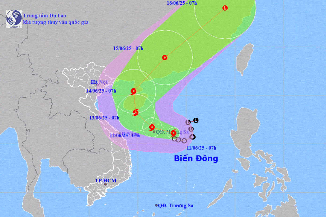
According to the National Center for Hydro-Meteorological Forecasting, at 1:00 p.m. on August 17, the center of the tropical depression was located at about 17.4 degrees North latitude; 111.1 degrees East longitude. The strongest wind near the center of the tropical depression was level 6 (39-49 km/h), gusting to level 8; moving northwest at a speed of about 15 km/h.
Disaster risk level 3
Commenting specifically on the development of the tropical depression, Deputy Director of the National Center for Hydro-Meteorological Forecasting Nguyen Xuan Hien said that as of 1:00 p.m. on August 18, the tropical depression was in the northern Gulf of Tonkin with strong winds of level 6, gusting to level 8; moving northwest at a speed of about 15 km/h. The affected area is the western sea area of the northern East Sea (including the Hoang Sa special zone), the Gulf of Tonkin (including the Bach Long Vi special zone). The natural disaster risk level is level 3.
At 1 p.m. on August 19, a tropical depression in the southern part of Guangxi Province (China) with winds below level 6 moved northwest at a speed of 10-15 km/h and gradually weakened into a low pressure area. The affected area is the northern part of the Gulf of Tonkin (including Bach Long Vi and Co To special zones). Disaster risk level 3.
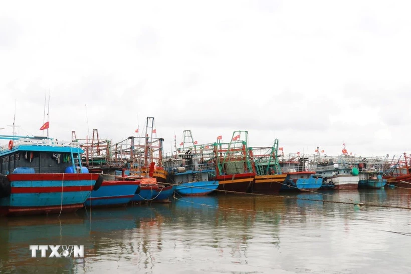 |
| Proactively responding to tropical depression. (Photo: Nguyen Ly/VNA) |
Due to the impact of the tropical depression, the western sea area of the North East Sea (including the Hoang Sa special zone) has thunderstorms and strong winds of level 6-7, gusts of level 8-9, waves of 2-3.5m high, and rough seas. From the evening of August 17, the Bac Bo Gulf area has gradually stronger winds of level 6, gusts of level 8, waves of 2-3m high, and rough seas.
Ships operating in the above mentioned dangerous areas are likely to be affected by storms, whirlwinds, strong winds and large waves.
Beware of flash floods and landslides in 4 Central provinces
According to the National Center for Hydro-Meteorological Forecasting, from 2:40 p.m. to 7:40 p.m. on August 17, the provinces of Thanh Hoa, Nghe An, Ha Tinh and Quang Tri continued to have rain with common accumulated rainfall as follows: Thanh Hoa and Nghe An from 20-50 mm, some places over 100 mm; Ha Tinh from 20-35 mm, some places over 70 mm; Quang Tri from 10-20 mm, some places over 40 mm.
Risk of flash floods on small rivers and streams, landslides on steep slopes in many communes/wards: Hoa Quy, Hop Tien, Luan Thanh, Mau Lam, Nhu Thanh, Nhu Xuan, Tan Thanh, Thang Loc, Thanh Quan, Thuong Ninh, Xuan Du; Thanh Phong, Xuan Binh, Xuan Thai, Yen Tho; An Nong, Ba Thuoc, Bat Mot, Cam Tan, Cam Thach, Cam Thuy, Cam Tu, Cam Van, Cong Chinh, Dien Lu, Dien Quang, Dinh Tan, Dong Luong, Giao An, Hien Kiet, Hoi Xuan, Kien Tho, Kim Tan, Lam Son, Linh Son, Luong Son, Minh Son, Muong Min, Na Meo, Nam Xuan, Ngoc Lac, Ngoc Lien, Nguyet An, Nong Cong, Phu Xuan, Pu Luong, Quan Son, Quy Loc, Quy Luong, Sao Vang, Son Dien, Son Thuy, Tam Lu, Tam Thanh, Tan Ninh, Tay Do, Thach Binh, Thach Lap, Thang Binh, Thanh Ky, Thien Phu, Thiet Ong, Thieu Hoa, Thieu Tien, Thieu Toan, Thieu Trung, Tho Binh, Tho Lap, Tho Long, Tho Ngoc, Tho Phu, Tho Xuan, Thuong Xuan, Trieu Son, Trung Ha, Trung Ly, Truong Lam, Van Nho, Van Phu, Van Xuan, Vinh Loc, Xuan Chinh, Xuan Hoa, Xuan Lap, Xuan Tin, Yen Dinh, Yen Khuong, Yen Nhan, Yen Ninh, Yen Phu, Yen Thang, Yen Truong ( Thanh Hoa province);
Bich Hao, Hoa Quan, Kim Bang, Son Lam, Tam Dong, Van An, Xuan Lam; Anh Son, Anh Son Dong, Cat Ngan, Con Cuong, Dai Dong, Dong Hieu, Hanh Lam, Minh Hop, Mon Son, Muong Chong, Nghia Hung, Tay Hieu, Quy Hop, Tam Hop, Tan Ky, Thuan Trung, Vinh Tuong, Yen Xuan; Bac Ly, Bach Ngoc, Binh Chuan, Binh Minh, Cam Phuc, Chau Binh, Chau Hong, Chau Khe, Chau Loc, Chau Tien, Chieu Luu, Do Luong, Giai Lac, Giai Xuan, Hung Chan, Huoi Tu, Huu Khuong, Huu Kiem, Keng Du, Luong Minh, Luong Son, Mau Thach, Muong Ham, Muong Long, Muong Quang, Muong Tip, Muong Xen, My Ly, Na Loi, Na Ngoi, Nam Can, Nga My, Nghia Dan, Nghia Dong, Nghia Hanh, Nghia Khanh, Nghia Lam, Nghia Loc, Nghia Mai, Nghia Tho, Nhan Hoa, Nhon Mai, Hoang Mai, Thai Hoa, Quang Dong, Que Phong, Quy Chau, Quynh Thang, Tam Quang, Tam Thai, Tan An, Tan Phu, Thanh Binh Tho, Thong Thu, Tien Dong, Tien Phong, Tri Le, Tuong Duong, Van Du, Yen Hoa, Yen Na ( Nghe An province);
Co Dam, Ky Hoa, Nghi Xuan, Vung Ang Ward, Son Giang, Son Kim 2; Cam Hung, Cam Lac, Can Loc, Duc Quang, Hong Loc, Huong Khe, Huong Son, Huong Xuan, Kim Hoa, Ky Khang, Ky Lac, Ky Thuong, Ky Van, Ky Xuan, Hoanh Son, Song Tri, Son Hong, Son Kim 1, Son Tay, Son Tien; Cam Due, Cam Trung, Cam Xuyen, Duc Dong, Duc Minh, Duc Tho, Ha Linh, Huong Binh, Huong Do, Huong Pho, Ky Anh, Mai Hoa, Mai Phu, Bac Hong Linh, Hai Ninh, Nam Hong Linh, Phuc Trach, Thach Khe, Thach Xuan, Thuong Duc, Truong Luu, Tu My, Tung Loc, Vu Quang (Ha Tinh province);
Kim Phu, Tuyen Binh; Ben Quan, Con Tien, Dan Hoa, Dong Le, Hai Lang, Kim Dien, Minh Hoa, Quang Tri, Phu Trach, Quang Ninh, Ta Rut, Trieu Phong, Tuyen Lam, Tuyen Phu, Tuyen Son (Quang Tri province).
Flash floods and landslides can have very negative impacts on the environment, threaten people's lives; cause local traffic congestion, affect the movement of vehicles; destroy civil and economic works, causing damage to production and socio-economic activities.
The Hydrometeorological Agency recommends that local authorities pay attention to reviewing bottlenecks and vulnerable locations in the area to take preventive and response measures.
From 7:00 p.m. on August 16 to 1:00 p.m. on August 17, the provinces of Thanh Hoa, Nghe An, Ha Tinh and Quang Tri had moderate rain, heavy rain, and very heavy rain in some places such as: Trieu Son (Thanh Hoa) 194.4mm; Yen Thuong (Nghe An) 164 mm, Do Luong (Nghe An) 137.6mm; Ky Thinh (Ha Tinh) 176.4mm, Ky Anh (Ha Tinh) 129.4mm; Tan Lam (Quang Tri) 72.4mm;...
Soil moisture models show that some areas in the above provinces are close to saturation (over 85%) or have reached saturation.
According to VNA/Vietnam+
Source: https://baoquangtri.vn/xa-hoi/202508/ap-thap-nhiet-doi-di-chuyen-theo-huong-tay-bac-huong-ve-khu-vuc-bac-vinh-bac-bo-4ac5fb4/


![[Photo] An Phu intersection project connecting Ho Chi Minh City-Long Thanh-Dau Giay expressway behind schedule](https://vstatic.vietnam.vn/vietnam/resource/IMAGE/2025/8/21/1ad80e9dd8944150bb72e6c49ecc7e08)
![[Photo] Politburo works with Standing Committees of Lang Son and Bac Ninh Provincial Party Committees](https://vstatic.vietnam.vn/vietnam/resource/IMAGE/2025/8/20/0666629afb39421d8e1bd8922a0537e6)


![[Photo] Politburo works with the Standing Committee of Hanoi Party Committee and Ho Chi Minh City Party Committee](https://vstatic.vietnam.vn/vietnam/resource/IMAGE/2025/8/21/4f3460337a6045e7847d50d38704355d)


Comment (0)