
 |
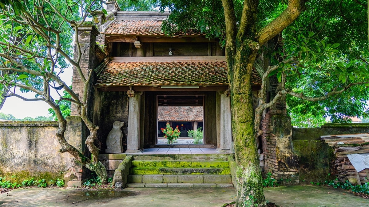
| Hoang Sa Exhibition House – where indisputable truths about Vietnam’s Hoang Sa are preserved. Photo: Thanh Hoa/vietnam.vnanet.vn |
Our country's sea area is about 1 million square kilometers, 3 times the land area, accounting for nearly 30% of the East Sea area. Our country's sea area has thousands of large and small islands distributed quite evenly along the coastline and two outpost archipelagos of the Fatherland, Hoang Sa and Truong Sa.
Historical and legal evidence of Vietnam's sovereignty over these two archipelagos has been and is being affirmed by many countries, the international community and many scientists: The Vietnamese State is the first state in history to possess and exercise its sovereignty over these two archipelagos.
 |
| Exhibition space introducing the authority and functions of the Hoang Sa Fleet established by the Nguyen Lords of Dang Trong in the 17th century. Photo: Thanh Hoa/vietnam.vnanet.vn |
Vietnam's occupation and exercise of sovereignty over these two archipelagos are clear, continuous, peaceful, and in accordance with the current principle of territorial acquisition - the principle of real occupation - of international law.
Hoang Sa and Truong Sa archipelagos in maps from the 17th century show: the two archipelagos are shown as a continuous strip, including Hoang Sa and Van Ly Truong Sa and were initially called by the Vietnamese with the common name Bai Cat Vang (shown in the ancient map of Vietnam called "Toan tap Thien Nam tu chi lo do thu" compiled by geographer Do Ba and completed in 1686).
In the first half of the 17th century, Lord Nguyen organized the "Hoang Sa team" taking people from An Vinh commune, Binh Son district, Quang Nghia prefecture to go to Hoang Sa archipelago to collect goods and equipment from stranded ships and catch rare seafood to bring back as tribute. Lord Nguyen also organized the "Bac Hai team" taking people from Tu Chinh village or Canh Duong commune, Binh Thuan prefecture, and issued permits to go to Truong Sa archipelago with the same mission as the Hoang Sa team.
 |
| Exhibition space introducing Vietnam's sovereignty over Hoang Sa through ancient maps and documents from the Nguyen Dynasty (1802-1945). Photo: Thanh Hoa/vietnam.vnanet.vn |
Throughout three centuries, from the 17th century to the end of the 19th century, despite going through many different dynasties, the Vietnamese monarchy established and implemented management activities and exercised Vietnam's sovereignty over the Hoang Sa and Truong Sa archipelagos without encountering any disputes or resistance.
This fact is proven in many documents, ancient books, legal documents of the State, maps showing the implementation of Vietnam's sovereignty over the two archipelagos of Hoang Sa and Truong Sa preserved in Vietnam and many countries around the world such as: Complete set of Thien nam tu chi lo do thu collected, compiled and completed in 1686 by Do Ba, also known as Cong Dao; Phu bien tap luc by Le Quy Don (1776); Lich trieu hien chuong loai chi by Phan Huy Chu (1821); Hoang Viet dia du chi (1833); Dai Nam thuc luc tien bien (1844-1848); Dai Nam thuc luc chinh bien (1844-1848), Viet su cuong giam khao luoc (1876), Dai Nam nhat thong chi (1882)...
In particular, the World Atlas by Philipe Vandemaelen published in 1827 in Belgium clearly depicted and described the Hoang Sa archipelago as belonging to the territory of the Kingdom of Annam.
In addition, the Nguyen Dynasty's Imperial Records are official administrative documents of the Nguyen Dynasty (1802-1945) with the king's seal, which are important evidence affirming that the Vietnamese monarchy established and implemented many activities to exercise sovereignty over the two archipelagos, such as annually sending the Bac Hai teams, concurrently managing the Hoang Sa team, to the two archipelagos to exploit marine resources and collect goods from sunken ships; surveying and drawing maps; erecting steles, building temples, planting trees, and providing relief to foreign ships in distress... These are valuable documents left by the Nguyen Dynasty for future generations. The Imperial Records have been recognized by UNESCO as an international documentary heritage...
In 1975, along with the process of completely liberating the South and unifying the country, the Vietnam People's Navy liberated the islands occupied by the Saigon army, such as Truong Sa, Son Ca, Nam Yet, Song Tu Tay, Sinh Ton and An Bang islands... belonging to the Truong Sa archipelago. At the same time, the Provisional Revolutionary Government of the Republic of South Vietnam issued a statement affirming Vietnam's sovereignty over the Hoang Sa and Truong Sa archipelagos.
On July 2, 1976, at the first session of the 6th National Assembly (1976-1981), the National Assembly of the unified Vietnam elected on April 25, 1976, decided to change the country's name to the Socialist Republic of Vietnam. The Socialist Republic of Vietnam continued to manage and protect Vietnam's sovereignty over the Hoang Sa and Truong Sa archipelagos, through many activities, both ensuring full and correct procedures in terms of legal struggle, and ensuring the consolidation and maintenance of the presence of the military and civilians on the geographical entities currently under the management of the Socialist Republic of Vietnam.
In particular, in 1982, Vietnam established Hoang Sa district and Truong Sa district, which now belong to Da Nang city, Truong Sa district belongs to Khanh Hoa province. In Truong Sa district, there are smaller units, such as Truong Sa town (including Truong Sa large island and its vicinity); Song Tu Tay commune (Song Tu Tay island and its vicinity); Sinh Ton commune (Sinh Ton island and its vicinity)...
Thus, Vietnam has sufficient historical evidence with legal value to prove and protect its sovereignty over these two archipelagos throughout historical periods.
It should be remembered that the Resolution of the United Nations General Assembly on October 24, 1970 clearly stated: "The territory of a State shall not be the object of military occupation resulting from the use of force in contravention of the provisions of the Charter of the United Nations. The territory of a State shall not be the object of acquisition by another State resulting from the threat or use of force. Any acquisition of territory resulting from the threat or use of force shall be illegal".
Therefore, China's use of force to occupy Hoang Sa - an inseparable part of Vietnam's territory on January 19, 1974 - is contrary to international law and cannot bring legal title to this country over the Hoang Sa archipelago.
Hoang Sa is still a part of Vietnam's territory!
Source
![[Photo] Binh Thuan organizes many special festivals on the occasion of April 30 and May 1](https://vphoto.vietnam.vn/thumb/1200x675/vietnam/resource/IMAGE/2025/5/1/5180af1d979642468ef6a3a9755d8d51)
![[Photo] Ha Giang: Many key projects under construction during the holiday season](https://vphoto.vietnam.vn/thumb/1200x675/vietnam/resource/IMAGE/2025/5/1/8b8d87a9bd9b4d279bf5c1f71c030dec)
![[Photo] "Lovely" moments on the 30/4 holiday](https://vphoto.vietnam.vn/thumb/1200x675/vietnam/resource/IMAGE/2025/5/1/26d5d698f36b498287397db9e2f9d16c)


Comment (0)