

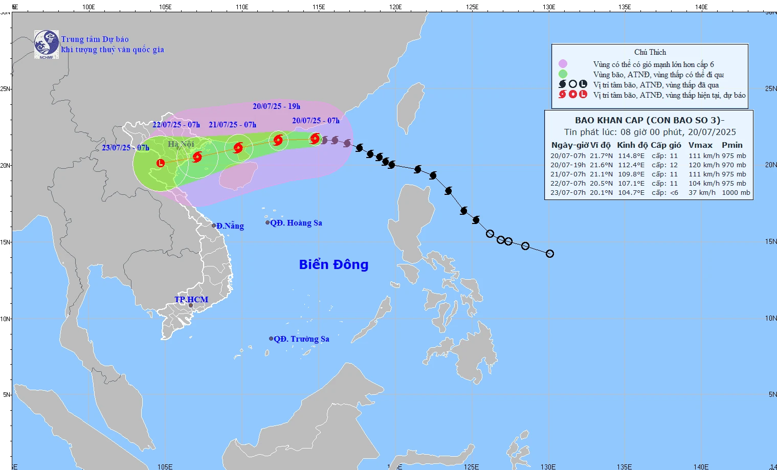
Forecast path of storm No. 3 at 8:00 a.m. on July 20, 2025.
According to the latest bulletin from the National Center for Hydro-Meteorological Forecasting, at 7:00 a.m. on July 20, the center of the storm was located at about 21.7 degrees North latitude; 114.8 degrees East longitude, in the northern sea area of the North East Sea, about 705km east of Quang Ninh - Hai Phong . The strongest wind near the center of the storm is level 11 (103-117km/h), gusting to level 14; moving in the West Northwest direction at a speed of about 20-25km/h.
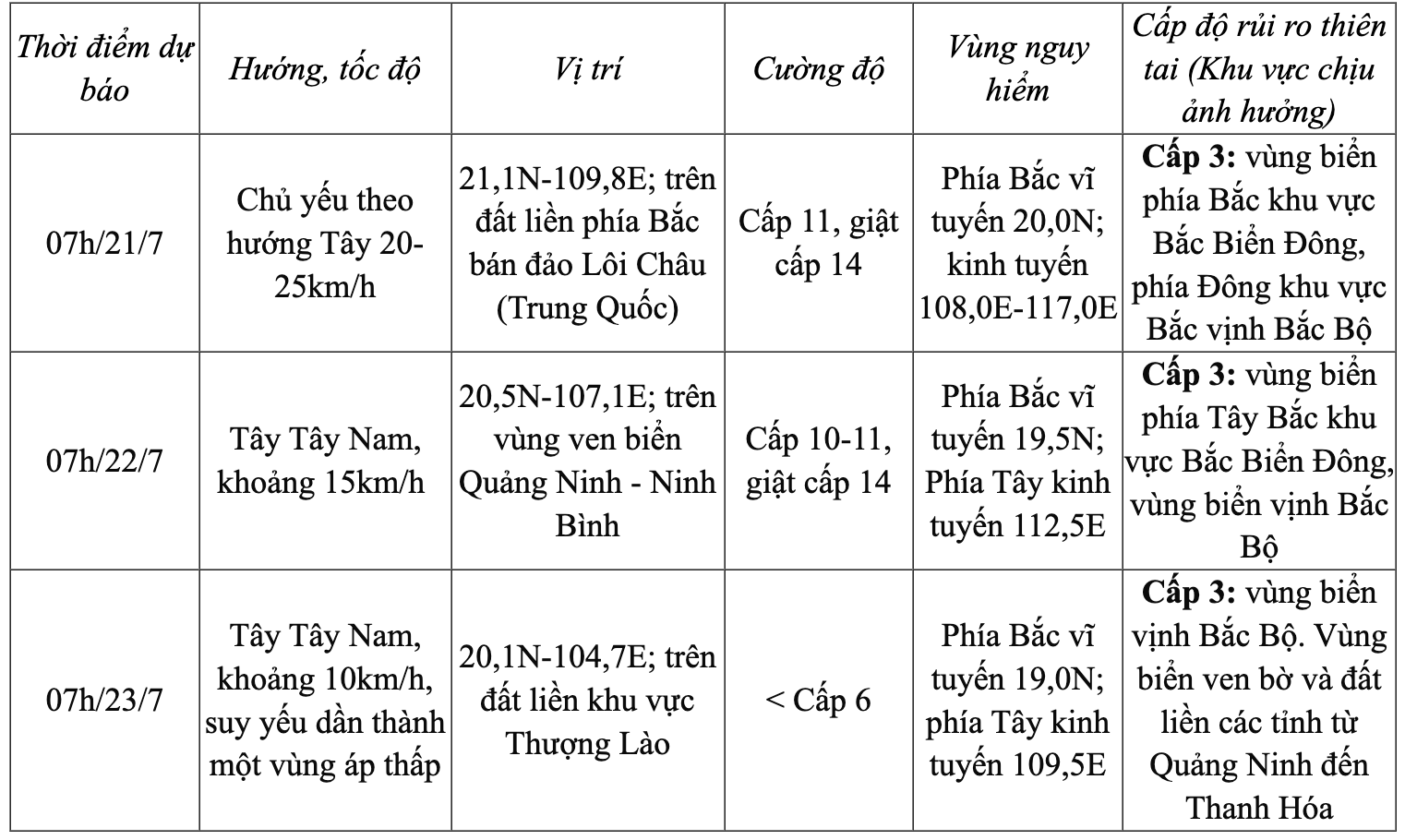
Storm forecast (next 24 to 72 hours) as follows:
Forecasting the impact of storms
Strong winds, big waves, rising sea levels
The northern sea area of the North East Sea has strong winds of level 8-10, near the storm center, winds of level 11-12, gusts of level 15; waves of 5-7m high. The sea is very rough.
From the night of July 20, the northern Gulf of Tonkin (including the special zones of Bach Long Vi, Co To, and Cat Hai) will have winds gradually increasing to level 6-7, then increasing to level 8-9, near the storm's eye level 10-11, gusting to level 14; waves 2-4m high, near the eye 3-5m. The sea will be very rough.
From July 21, the sea in the southern Gulf of Tonkin will have winds gradually increasing to level 6-7, near the storm center level 8-9, gusting to level 11, waves 2-4m high. The sea is very rough.
Ships operating in the above mentioned dangerous areas are likely to be affected by storms, whirlwinds, strong winds and large waves.
Storm surge and coastal flood warnings
The coastal area of Hai Phong - Quang Ninh has storm surges of 0.5-1m high, the water level at Hon Dau (Hai Phong) is 3.8-4.1m high, at Cua Ong ( Quang Ninh ) is 4.8-5.2m high. There is a high risk of flooding in low-lying coastal and river mouth areas at noon and afternoon on July 22.
From the evening and night of July 21, on the mainland from Quang Ninh to Thanh Hoa, winds will gradually increase to level 7-9, gusting to level 10-11; further inland, winds will increase to level 6-7, gusting to level 8-9; near the storm center, winds will increase to level 10-11, gusting to level 14.
Heavy rain
From July 21 to July 23, in the Northern and North Central regions, there is a possibility of widespread heavy rain with common rainfall of 100-200mm, locally over 300mm; in the Northeast, Northern Delta, Thanh Hoa and Nghe An, there will be heavy to very heavy rain with common rainfall of 200-350mm, locally over 600mm. Warning of the risk of heavy rain (>150mm/3h).
NDS
Source: https://baothanhhoa.vn/bao-so-3-cach-quang-ninh-hai-phong-khoang-705km-ve-phia-dong-255398.htm


![[Photo] An Phu intersection project connecting Ho Chi Minh City-Long Thanh-Dau Giay expressway behind schedule](https://vstatic.vietnam.vn/vietnam/resource/IMAGE/2025/8/21/1ad80e9dd8944150bb72e6c49ecc7e08)


![[Photo] Politburo works with the Standing Committee of Hanoi Party Committee and Ho Chi Minh City Party Committee](https://vstatic.vietnam.vn/vietnam/resource/IMAGE/2025/8/21/4f3460337a6045e7847d50d38704355d)


Comment (0)