
Specifically, according to the National Center for Hydro-Meteorological Forecasting, at 7:00 a.m., the eye of the storm was located in the sea east of the central Philippines. The strongest wind near the eye of the storm was level 16 (184-201 km/h), gusting to level 17. The super typhoon moved in a West-Northwest direction at a speed of 20-25 km/h.
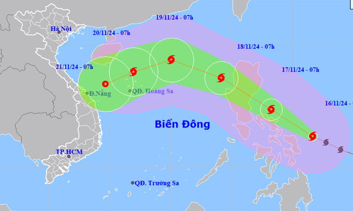
Typhoon Man-yi has strengthened into a super typhoon, moving at a speed of 20-25km/h, approaching the East Sea. (Source: NCHMF)
Forecast in the next 24 hours, the center of the super typhoon is located in the sea east of the central Philippines, changing direction to the northwest, traveling 20-25km per hour. The super typhoon enters the East Sea, becomes the 10th storm of 2024 and gradually weakens. The strongest wind near the center of the storm is level 16, gusting above level 17.
Forecast by 7am on November 18, storm No. 10 in the eastern sea area of the North East Sea, changing direction to West Northwest and moving slowly at a speed of 15-20km. The strongest wind near the storm center is level 12, gusting to level 15.
At around 7am on November 19, the storm was moving west-northwest in the North East Sea at a speed of 15-20km/h, about 460km east-northeast of the Hoang Sa archipelago. The strongest wind near the storm's center was at level 12, gusting to level 15.
From the next 72 to 120 hours, storm No. 10 will move in the West Southwest direction, traveling 10-15km per hour, and its intensity will continue to weaken.
From the afternoon of November 17, the sea area east of the North East Sea has strong winds of level 6-7, then increasing to level 8-9, the area near the storm's eye has winds of level 10-12, gusts of level 16, waves 2-4m high, the area near the storm's eye has waves of 5-7m, the sea is very rough.
All vessels operating in the above areas are at high risk of being affected by cyclones, strong winds and large waves.
In addition, according to information shared on the Fanpage of the Vietnam General Department of Hydrometeorology, from November 16 to 21, the Central region will have rain in some places, of which, the North and Central Central regions from November 17 to 19 will have rain, scattered showers and thunderstorms in some places, locally moderate rain, heavy rain.
From the night of November 21-22, Nghe An to Binh Dinh will have rain, showers and scattered thunderstorms, locally heavy to very heavy rain, other places will have thunderstorms in some places.
From the night of November 19, the North Central region will have cold nights and mornings.
During thunderstorms there is a possibility of tornadoes, lightning and strong gusts of wind.
On November 21-23, there is a possibility of a flood on rivers from Quang Binh to Quang Ngai, other rivers in the Central region will fluctuate.
Video: Weather forecast for November 16
Source: https://vtcnews.vn/bao-man-yi-manh-len-cap-sieu-bao-du-bao-mien-trung-sap-hung-mua-lon-ar907716.html


![[Photo] Solemn opening of the 9th Session, 15th National Assembly](https://vphoto.vietnam.vn/thumb/1200x675/vietnam/resource/IMAGE/2025/5/5/ad3b9de4debc46efb4a0e04db0295ad8)

![[Photo] President Luong Cuong presided over the welcoming ceremony and held talks with Sri Lankan President Anura Kumara Dissanayaka](https://vphoto.vietnam.vn/thumb/1200x675/vietnam/resource/IMAGE/2025/5/5/bbb34e48c0194f2e81f59748df3f21c7)


![[Photo] National Assembly delegates visit President Ho Chi Minh's Mausoleum](https://vphoto.vietnam.vn/thumb/1200x675/vietnam/resource/IMAGE/2025/5/5/9c1b8b0a0c264b84a43b60d30df48f75)


Comment (0)