
"The publication by the Chinese Ministry of Natural Resources of the so-called "2023 standard map" which includes Vietnam's Hoang Sa and Truong Sa archipelagos and shows the dotted line claim is a violation of Vietnam's sovereignty over the Hoang Sa and Truong Sa archipelagos, as well as Vietnam's sovereignty, sovereign rights and jurisdiction over its maritime zones as determined under the 1982 United Nations Convention on the Law of the Sea.
Therefore, the sovereignty claim and maritime claim based on the dashed line as shown in the above map are invalid and violate international law, especially the 1982 United Nations Convention on the Law of the Sea.
Once again, Vietnam strongly affirms its consistent stance on the issue of sovereignty over the Hoang Sa and Truong Sa archipelagos, as well as resolutely opposes all claims by China in the East Sea based on the dashed line."

Spokesperson of the Ministry of Foreign Affairs of Vietnam Pham Thu Hang. Photo: VNA
Last Monday, China published a map with an illegal "cow tongue line" covering about 90% of the East Sea area.
The Philippines on Thursday called on China to “act responsibly and comply with its obligations” under international law and a 2016 arbitration ruling that declared the dashed line had no legal basis.
“This latest attempt to legitimize China’s sovereignty and jurisdiction… has no basis under international law,” the Philippine Department of Foreign Affairs said.
Malaysia said it had lodged a diplomatic protest over the map and said in a statement that China's new map had no legal basis.
This map differs from a narrower version submitted by China and rejected by the United Nations in 2009 on the South China Sea, which included the so-called “nine-dash line.” China’s new map has a 10-dash line.
India also said on Tuesday that it had strongly protested to China over the new map, which lays claim to Indian territory.
Huy Hoang (according to VNA, Reuters)
Source

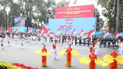
![[Photo] Panorama of the parade celebrating the 50th anniversary of the Liberation of the South and National Reunification](https://vphoto.vietnam.vn/thumb/1200x675/vietnam/resource/IMAGE/2025/4/30/affbd72e439d4362962babbf222ffb8b)
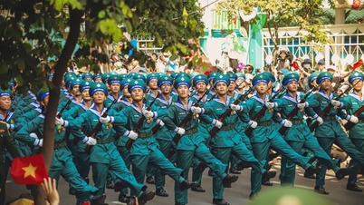
![[Photo] The parade took to the streets, walking among the arms of tens of thousands of people.](https://vphoto.vietnam.vn/thumb/1200x675/vietnam/resource/IMAGE/2025/4/30/180ec64521094c87bdb5a983ff1a30a4)


![[Photo] "King Cobra" Su-30MK2 completed its glorious mission on April 30](https://vphoto.vietnam.vn/thumb/1200x675/vietnam/resource/IMAGE/2025/4/30/5724b5c99b7a40db81aa7c418523defe)


![[Photo] Cultural, sports and media bloc at the 50th Anniversary of Southern Liberation and National Reunification Day](https://vphoto.vietnam.vn/thumb/1200x675/vietnam/resource/IMAGE/2025/4/30/8a22f876e8d24890be2ae3d88c9b201c)


Comment (0)