

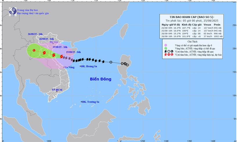
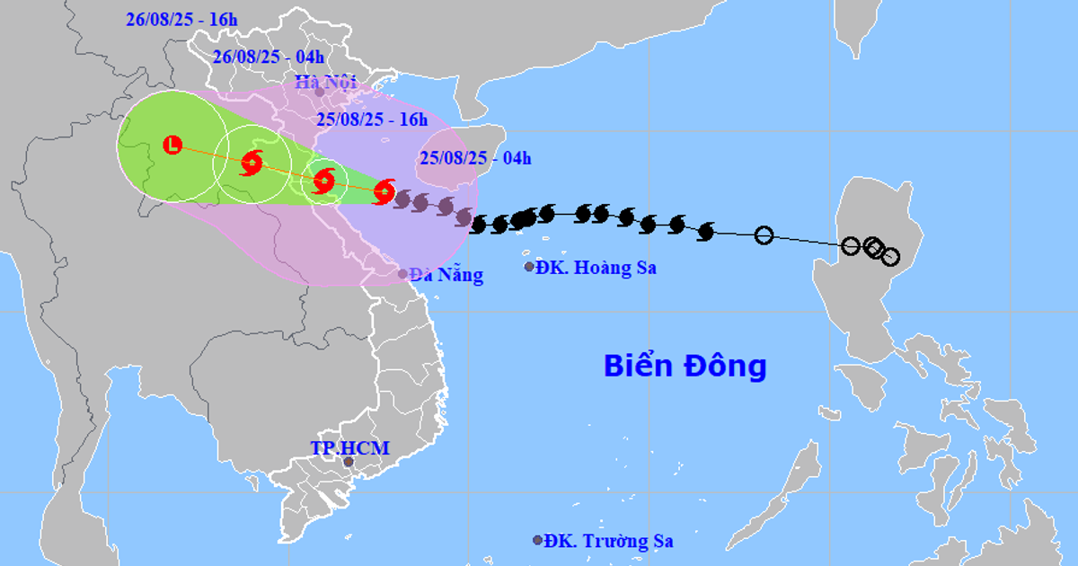
Forecast map of storm No. 5's trajectory and intensity released at 5:00 a.m. on August 25.
The strongest wind near the storm center is level 14 (150-166km/h), gusting to level 17, moving west-northwest at a speed of about 20km/h.
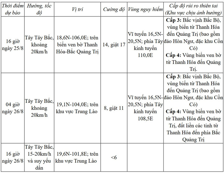
Storm forecast (in the next 12 to 36 hours):
Due to the influence of storm No. 5, at Bach Long Vi station ( Hai Phong ) there are strong winds of level 7, gusts of level 9, at Co To station (Quang Ninh) there are strong winds of level 6, gusts of level 9, at Bai Chay station (Quang Ninh) there are strong winds of level 6, gusts of level 8, at Hon Ngu station (Nghe An) there are strong winds of level 7, gusts of level 8, at Con Co station (Quang Tri) there are strong winds of level 6, gusts of level 8, ...
Strong winds, big waves, rising water
At sea: In the western sea area of the northern East Sea on August 25, there will be strong winds of level 6-7, gusts of level 9, waves 3-5m high, and rough seas.
The sea area from Thanh Hoa to Quang Tri (including Hon Ngu island, Con Co special zone) has strong winds of level 7-9, then increasing to level 10-11, the area near the storm's eye has winds of level 12-14, gusts of level 17, waves 5-7m high, the area near the storm's eye has winds of 8-10m; the sea is very rough. The northern Gulf of Tonkin (including the special zones: Cat Hai, Co To, Van Don) has strong winds of level 6-7, gusts of level 9, especially the southern area of the northern Gulf of Tonkin (including the special zone Bach Long Vi) has strong winds of level 8-9, gusts of level 11, waves 3-5m high, the sea is very rough.
Storm surge and flood warnings for coastal areas and islands from Hai Phong to Northern Quang Tri have storm surges of 0.5-1.8m, with Thanh Hoa and Nghe An having 1-1.8m. Water levels at Hon Dau (Hai Phong) are 3.5-4m high, Ba Lat (Ninh Binh) 1.8-2.3m, Sam Son (Thanh Hoa) 3.7-4.2m, Hon Ngu (Nghe An) 3.5-4m, and Cua Nhuong ( Ha Tinh ) 2.2-2.6m.
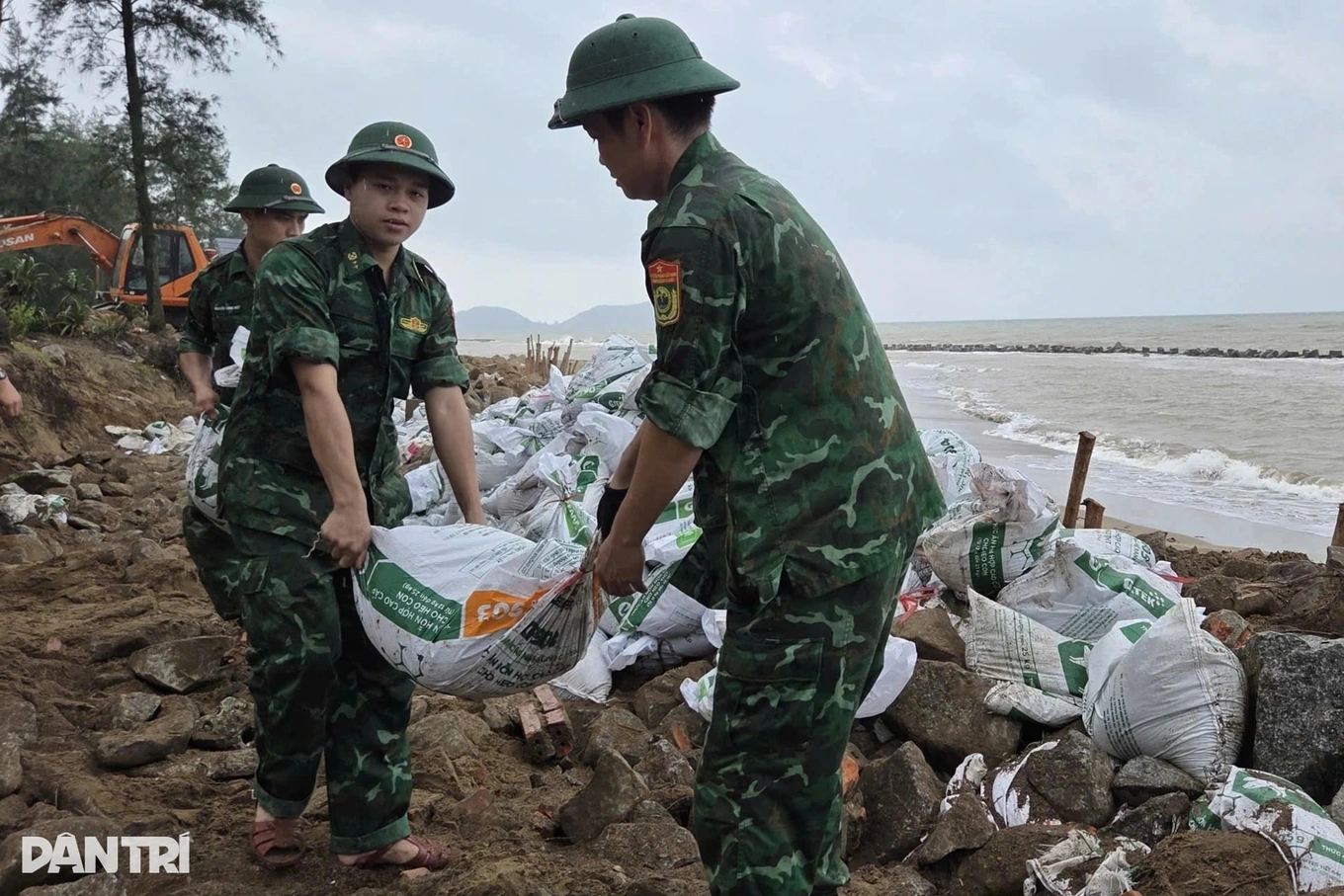
There is a high risk of flooding on dykes, coastal roads, and river mouths due to rising water and very high storm waves in the afternoon and evening of August 25.
Weather warnings at sea and coastal areas during storms are extremely dangerous and unsafe for any vehicles or structures operating in dangerous areas such as: cruise ships, passenger ships, cargo ships, cages, rafts, aquaculture areas, dykes, embankments, coastal routes. Vehicles are at high risk of capsizing, destruction, and flooding due to strong winds, large waves, and rising sea levels.
On land: From the morning of August 25, on land from Thanh Hoa to Northern Quang Tri, winds will gradually increase to level 8-11, gusting to level 12-14. Particularly in the Southern Thanh Hoa-Ha Tinh area, winds will gradually increase to level 12-14, gusting to level 15-16. In coastal areas from Quang Ninh to Ninh Binh, winds will gradually increase to level 6-8, gusting to level 9-10.
From the morning of August 25 to the end of August 26, in the midlands and deltas of the North, Lao Cai area and from Thanh Hoa to Hue city, there will be widespread heavy rain with common rainfall of 100-150mm, locally over 250mm, especially in the area from Thanh Hoa to Northern Quang Tri, there will be heavy to very heavy rain with common rainfall of 200-400mm, locally over 700mm.
Warning of risk of heavy rain (>200mm/3 hours).
From August 25-26, the capital Hanoi area will have moderate rain, heavy rain and thunderstorms.
On August 25, Da Nang City will have rain, moderate rain and thunderstorms. From August 25-26, Ho Chi Minh City will have rain, showers and thunderstorms (thunderstorms concentrated in the afternoon and evening).
During thunderstorms, be aware of the risk of tornadoes and strong gusts of wind.
From the afternoon of August 25-27, the Upper and Central Laos regions had heavy rain with common rainfall of 100-250mm, especially in the Central Laos region, some places had over 500mm.
Nhandan.vn
Source: https://nhandan.vn/bao-so-5-giat-cap-17-cach-nghe-an-ha-tinh-quang-tri-khoang-200km-post903310.html


![[Photo] General Secretary To Lam attends the 80th anniversary of Vietnam's diplomacy](https://vstatic.vietnam.vn/vietnam/resource/IMAGE/2025/8/25/3dc715efdbf74937b6fe8072bac5cb30)


Comment (0)