

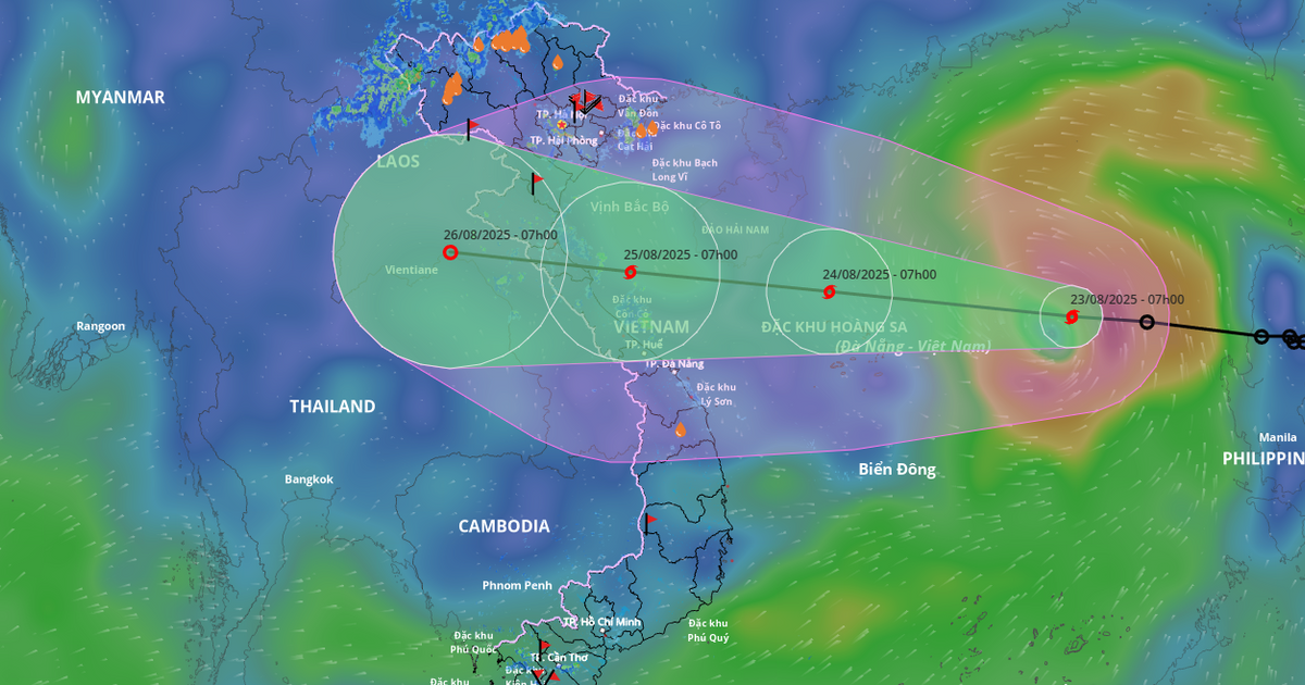
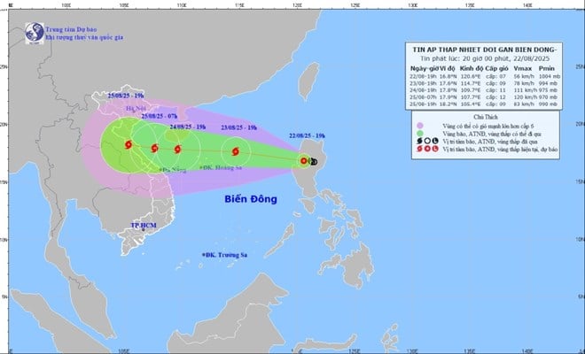
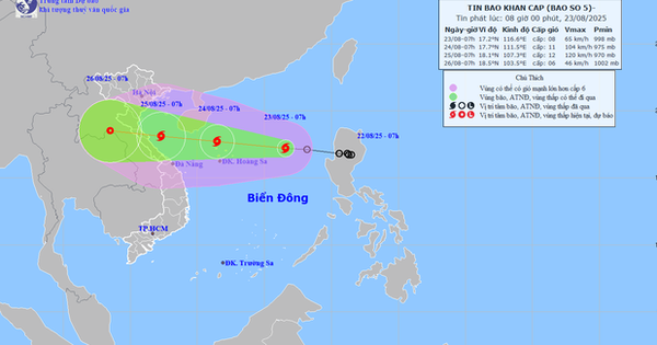
At 7:00 a.m. on August 22, the center of the tropical depression was at about 16.7 degrees North latitude; 121.5 degrees East longitude. The strongest wind near the center of the tropical depression was at level 6 (39-49 km/h), gusting to level 8; moving northwest at a speed of 10-15 km/h. It is forecasted that at about 7:00 a.m. on August 24, the tropical depression is likely to strengthen into a storm.
Due to the impact of the tropical depression later strengthening into a storm, the sea area from Lam Dong to Ca Mau (including the sea area of Ho Chi Minh City) has southwest wind level 4, sometimes level 5, wave height 1.0-2.0m, the weather has scattered showers and thunderstorms. During thunderstorms, beware of tornadoes and strong gusts of wind.
In the coming days, the sea area of Ho Chi Minh City (including Con Dao station and DK 1-7) will have scattered showers and thunderstorms, with the possibility of tornadoes and gusts of wind up to level 6. From August 25 to 26, the southwest wind will strengthen to level 6, gusting to level 7-8, waves 1.6-2.2m high, and seas will be slightly rough to rough, which can be dangerous for ships and boats.
The weather forecast for the coming days in the South and Ho Chi Minh City is cloudy, sunny during the day, sometimes intermittent, scattered showers and thunderstorms in the evening, some places have moderate to heavy rain. During thunderstorms, be careful of lightning, strong gusts of wind and tornadoes.

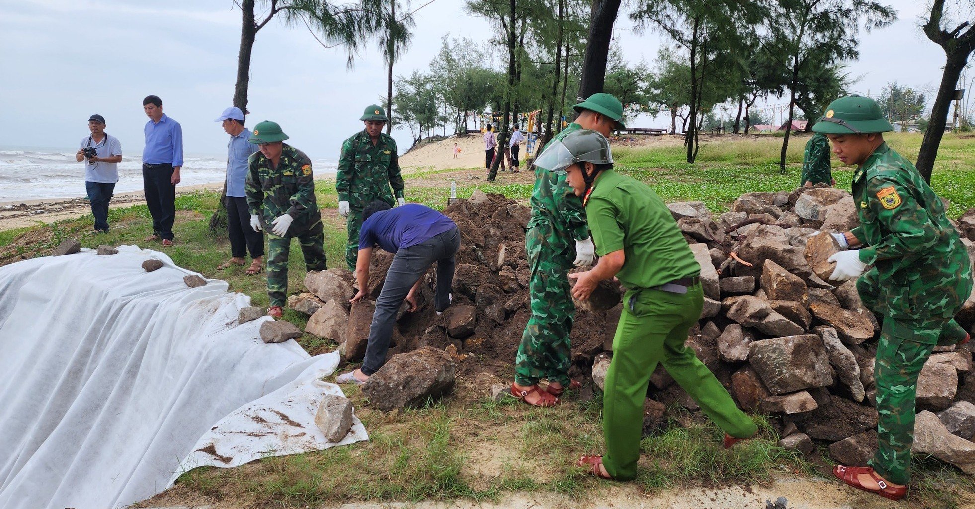
To proactively respond to natural disasters and storms, the Ho Chi Minh City Civil Defense - Natural Disaster Prevention and Search and Rescue Command has requested relevant units and localities to be ready to deploy plans to ensure safety for people and boats operating on rivers, at sea, in seaport waters and coordinate search and rescue work in the city. Prepare forces, vehicles and equipment to carry out search and rescue work when there is a situation.
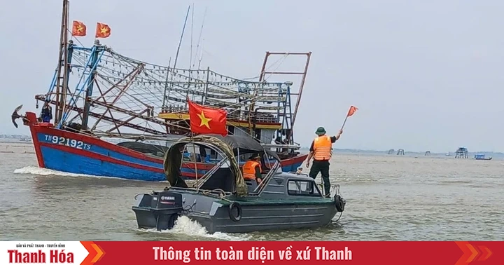
The People's Committees of Can Gio, An Thoi Dong, Thanh An (HCMC) and the Border Guard Command, the Department of Fisheries and Fisheries Surveillance of HCMC, and the City Coastal Information Station regularly inform vessels and boats operating at sea about the developments of tropical depressions and storms to have appropriate plans for production and exploitation of aquatic products. Organize monitoring, counting, and statistics of the number of vessels operating in the affected area; ensure communication with the owners of the vessels to provide guidance and timely handling of incidents.
The media and press agencies promptly reported warnings and forecasts of the development of tropical depressions that could strengthen into storms; and directive documents from the Central and the city for authorities at all levels to implement and for people in the city to proactively and effectively respond.
Source: https://www.sggp.org.vn/tphcm-chu-dong-ung-pho-ap-thap-nhiet-doi-bao-post809587.html

![[Photo] General Secretary To Lam attends the 80th Anniversary of the Cultural Sector's Traditional Day](https://vstatic.vietnam.vn/vietnam/resource/IMAGE/2025/8/23/9f771126e94049ff97692935fa5533ec)


Comment (0)