
Apnews' latest update on the planet's most powerful storm, Milton, shows that while it is weakening slightly, it is still a powerful storm that could hit Tampa and St. Petersburg head-on, unleashing record-breaking waves and turning debris from Hurricane Helene 12 days ago into flying objects.
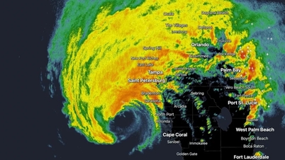
Hurricane Milton is expected to make landfall late Wednesday as a Category 3 storm on Florida's Gulf Coast, with the eye of the storm possibly hitting Tampa.
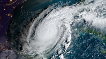
Before losing a level, Hurricane Milton in the Gulf of Mexico had strengthened into a Category 5 storm - the strongest on the Saffir–Simpson scale used in the US - with winds of 290 km/h, according to CNN. If calculated on the scale in Vietnam, it is above level 17 (level 17 winds are 202 - 220 km/h).
"At its peak, Milton surpassed the year's most intense storms in the Western Pacific to become the planet's strongest storm this year," according to CNN.
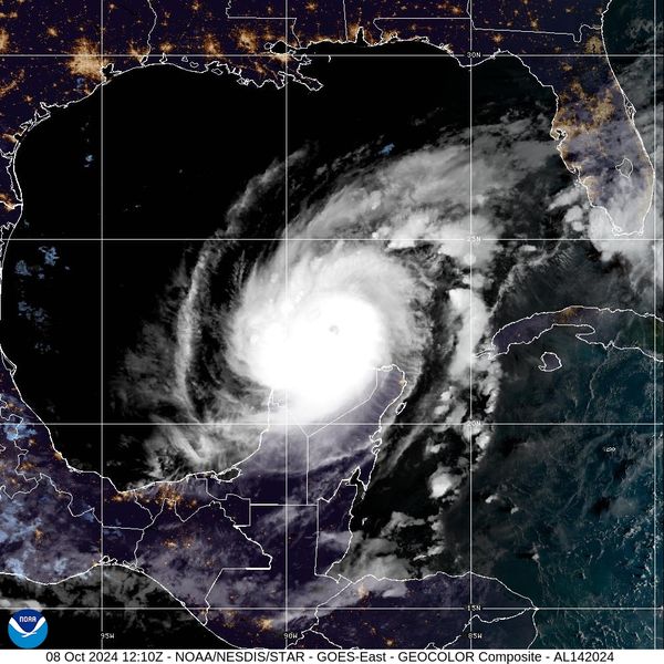
The strongest storm on the planet Milton: The storm is described as fierce and is heading towards Tampa Bay, Florida (USA). Photo: NHC.
Thus, Hurricane Milton has become the strongest hurricane in the world this year, surpassing Hurricane Beryl (maximum wind speed of 265.5 km/h), according to the US National Oceanic and Atmospheric Administration (NOAA).
Hurricane Milton has "burst into strength" in the southern Gulf of Mexico as it continues its path toward Florida, cbsnews reported. Milton underwent rapid intensification from a tropical storm on Sunday morning to a Category 5 hurricane in just 24 hours. Early Tuesday morning, it was back to Category 4.
The track of the system has been adjusted in each public advisory issued by the National Hurricane Center. Milton's forecast track is toward the west coast of Florida, but the location of the storm's center, or "eye," could impact the Tampa Bay area.
As Milton strengthened into a major hurricane with winds reaching more than 180 mph on Monday, the system's strength increased the severity of storm surge forecasts for all coastal areas, including Florida's Gulf Coast.
The US National Hurricane Center (NHC) has increased its forecast for a peak storm surge of 8-12 feet to 10-15 feet, flooding the area from the Anclote River to Tampa Bay. "Just two weeks after Hurricane Helene broke Tampa's storm surge record, Milton is forecast to produce an even higher storm surge," the NHC warned.
"Although fluctuations in intensity are expected, Milton is forecast to remain an extremely dangerous hurricane when it makes landfall in Florida," the NHC said in an earlier statement.
All coastal residents and visitors are being advised to comply with current evacuation orders from local officials.
Learning from Hurricane Helene, local authorities have asked residents to move to safety as quickly as possible. US media predict this will be the largest statewide evacuation since Hurricane Irma in 2017.
Hurricane warnings now cover both the east and west coasts of Florida as Hurricane Milton approaches.
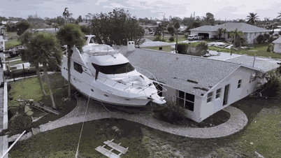
Having just suffered the devastating effects of Category 4 Hurricane Helene less than two weeks ago, Florida’s coastal counties are scrambling to prepare for Milton. Helene killed more than 225 people in Florida and five other southeastern states in late September, many of whom refused to evacuate.
Rescue crews on the peninsula that makes up Tampa Bay took precautions and removed beach chairs and other items that could become dangerous debris due to strong winds in Milton, CNN reported.
Elsewhere, stoves, chairs, refrigerators and kitchen tables were piled up waiting to be cleared away. Sarah Steslicki, who lives in Belleair Beach, said she was disappointed that more debris wasn’t picked up sooner.
“If this storm actually makes landfall, it will be flying missiles,” she told the Associated Press on Monday. “Those things will float and fly through the air.”
Source: https://danviet.vn/dien-bien-sieu-bao-manh-nhat-hanh-tinh-milton-con-bao-duoc-mo-ta-du-doi-tren-cap-17-dang-tien-thang-florida-my-20241008212008893.htm

![[Photo] Vietnam and Sri Lanka sign cooperation agreements in many important fields](https://vphoto.vietnam.vn/thumb/1200x675/vietnam/resource/IMAGE/2025/5/5/9d5c9d2cb45e413c91a4b4067947b8c8)


![[Photo] President Luong Cuong and Sri Lankan President Anura Kumara Dissanayaka visit President Ho Chi Minh relic site](https://vphoto.vietnam.vn/thumb/1200x675/vietnam/resource/IMAGE/2025/5/5/0ff75a6ffec545cf8f9538e2c1f7f87a)


Comment (0)