
TPO – Due to the high tide of the 15th day of the 8th lunar month combined with heavy rains and floods from the upper Mekong River, the water level of rivers in the Southwest region is rising rapidly, forecasting the risk of flooding in low-lying areas in the Mekong Delta from September 18 to 22.
According to the Southern Institute of Water Resources Planning, floods on the Mekong River in upper Laos and northern Thailand are showing a strong increase due to the impact of heavy rains from storm No. 3 (Yagi). Water levels in Cambodia are low but are expected to increase sharply due to floods from upstream.
Floods in the upper reaches of the Mekong River are expected to increase in the next 1 to 2 weeks due to increased upstream rain and floods, combined with high tides (mid-tide period in the 8th lunar month) and the possibility of reaching the September flood peak around September 19-22.
The water level at Tan Chau station is forecast to fluctuate between 3 - 3.2 m, 0.07 - 0.27 m higher than in 2023. The water level at Chau Doc station is between 2.8 - 3 m, 0.03 - 0.23 m higher than in 2023.
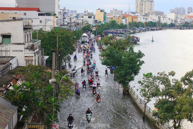 |
Flooding due to high tide in Tran Xuan Soan street area (District 7, HCMC). Photo: Huu Huy |
The flood peak at Can Tho station is forecasted to reach 2.05 - 2.15 m (0.05 - 0.15 m above Level III). The flood peak at My Thuan station is forecasted to reach 1.95 - 2.05 m (0.15 - 0.25 m above Level III).
In extreme cases, when the flood peak is combined with high tides, and there are additional unfavorable weather factors such as heavy rain and strong winds, the flood peak in Can Tho and My Thuan may be 5-10 cm higher than the above assessment.
Based on the above assessment results, the Southern Institute of Water Resources Planning said that there is a high risk of flooding due to high tides combined with heavy rains in low-lying areas in the Mekong Delta from September 18 to 22. In particular, flooding will occur in the central and coastal areas of the Mekong Delta including Can Tho City, Vinh Long Province; riverside districts and between the two rivers of Dong Thap Province; central areas of the Ca Mau Peninsula such as Vi Thanh City, Nga Bay City of Hau Giang Province; Phuoc Long and Hong Dan districts of Bac Lieu Province; Nga Nam Town, My Tu District of Soc Trang Province; Tran Van Thoi and Thoi Binh districts, Ca Mau City of Ca Mau Province and some areas in the upper Mekong Delta such as Long Xuyen City of An Giang Province.
Therefore, the Southern Institute of Water Resources Planning recommends that localities at risk of flooding due to high tides combined with heavy rain during the high tides from September 18 to 22 should pay attention to reviewing weak embankments, newly built embankments and developing timely response solutions.
For irrigation sub-regions with low embankment elevations such as in Ca Mau, Bac Lieu, Hau Giang and Kien Giang provinces, it is necessary to closely monitor rain forecasts and tidal developments to have timely drainage plans, and prepare pumping plans when flooding occurs...
Which areas in Ho Chi Minh City are likely to be flooded due to high tides?
According to the Southern Hydrometeorological Station, in the past 24 hours, water levels at stations downstream of the Saigon - Dong Nai river system have risen rapidly and remain low. As of 7:00 a.m. on September 16, the highest water levels of the day at Phu An and Nha Be stations were both below Alert Level I.
Water levels at the stations are forecast to continue to rise rapidly following the high tide of the 15th day of the 8th lunar month in the coming days. By September 18, the water level will be at BĐI – BĐII (1.40-1.50m).
The highest tide peak during this period is likely to appear from September 19 to 21 (ie August 17 to 19 of the lunar calendar) and reach the following levels:
At Phu An station (Sai Gon river), Nha Be station (Dong Dien canal) the level is from 1.58 - 1.65m (approximately or 0.05m higher than Alarm III). The peak tide time is from 5 - 7am and 5 - 7pm.
At Thu Dau Mot station (Sai Gon river) it is from 1.60 - 1.70m (approximately or 0.10m higher than BĐIII). At Bien Hoa station (Dong Nai river) it is from 1.90 - 1.95m (0.10 - 0.15m higher than BĐI).
The level of natural disaster risk in the downstream area of Saigon - Dong Nai river is at level 2.
High peak tide levels are likely to cause flooding in low-lying areas and riverside areas and affect traffic, daily life, and socio-economic activities in the Ho Chi Minh City area. Some roads in District 7 and Nha Be District (Ho Chi Minh City) may be flooded, such as: Tran Xuan Soan, Dao Su Tich, Huynh Tan Phat, Nguyen Binh, Le Van Luong, National Highway 50, Pham Huu Lau, etc.

Heavy rain in Ho Chi Minh City and the South in the new week

Heavy rain in Ho Chi Minh City and the South during the weekend

Ho Chi Minh City and the South welcome widespread and prolonged thunderstorms


![[Photo] Vietnam shines at Paris International Fair 2025 with cultural and culinary colors](https://vphoto.vietnam.vn/thumb/1200x675/vietnam/resource/IMAGE/2025/5/4/74b16c2a197a42eb97597414009d4eb8)


Comment (0)