
Heavy rains will peak in the Central region over the next two days, with the rain expanding from Ha Tinh to Quang Ngai. Around November 8, storm Yinxing is likely to enter the northeastern part of the East Sea, hindering the development of this rain wave.
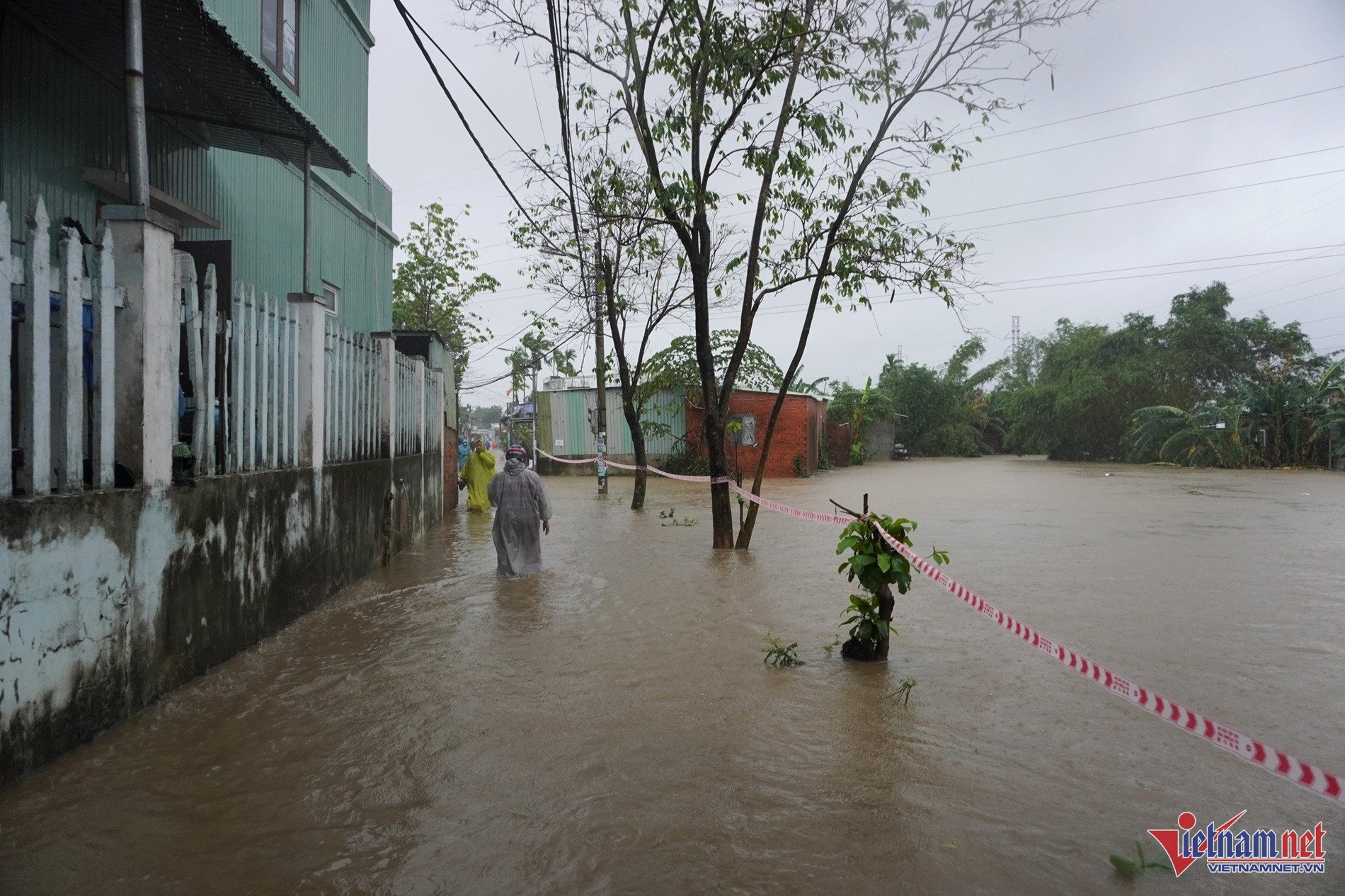
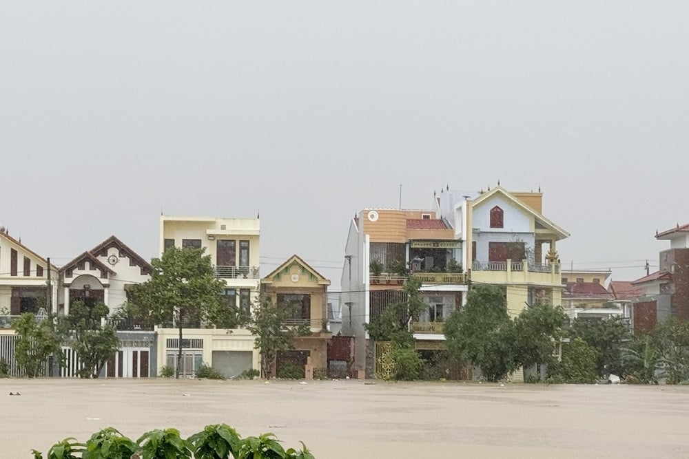
According to the National Center for Hydro-Meteorological Forecasting, today (November 5), in the area from Ha Tinh to Quang Ngai, there will be moderate rain, heavy rain, and locally very heavy rain. The rainfall from 7am to 3pm in some places was over 140mm such as: Lam Hoa (Ha Tinh) 145.6mm, Dong Tam (Quang Binh) 300.6mm, Thang Binh (Quang Nam) 175.0mm, Dong Nghe lake basin (Da Nang) 163mm, Loc Tien (Thua Thien Hue) 224.2mm, ...
It is forecasted that from this evening to tomorrow morning (November 6), the area from Ha Tinh to Binh Dinh will have heavy to very heavy rain with rainfall from 50-120mm, locally over 300mm. Warning of the risk of local heavy rain (>100mm/3 hours).
From tomorrow noon to the end of the 7th, the area from Quang Tri to Khanh Hoa will have moderate rain, locally heavy rain, some places very heavy rain with rainfall from 40-100mm, some places over 200mm. Warning of the risk of local heavy rain (>100mm/6 hours).
Warning level 2 of natural disaster risk due to heavy rain, tornadoes, and lightning in the area from Ha Tinh to Quang Ngai.
From the night of November 7, heavy rain in the Central region tends to gradually decrease.
In addition, tonight and tomorrow, in Ninh Thuan, Binh Thuan, Central Highlands and the South, there will be scattered showers and thunderstorms, locally heavy rain with rainfall from 15-30mm, locally over 60mm (rain concentrated in the afternoon and evening).
Mr. Phung Tien Dung, Head of Hydrological Forecasting Department, National Center for Hydro-Meteorological Forecasting, said that from now until November 9, there is a possibility of a flood on rivers from Ha Tinh to Quang Ngai. During this flood, the flood peak on rivers in Quang Binh will reach level 2-3; Ngan Sau and Ngan Pho rivers (Ha Tinh), rivers from Quang Tri to Quang Ngai will reach level 1-2 and above level 2.
Heavy rain combined with floods creates a high risk of flooding in urban areas, low-lying areas along rivers, flash floods and landslides on steep slopes in mountainous areas from Ha Tinh to Quang Ngai.
Typhoon Yinxing off the Philippines could enter the South China Sea
This afternoon, the Southern Hydrometeorological Station also released a general weather forecast for the next 10 days. Accordingly, in the next 1-2 days, cold air will continue to strengthen and diffuse southward. The low pressure trough with an axis of 5-8 degrees North latitude tends to slowly move southward. Above, the subtropical high pressure has an axis crossing the North and North Central regions. The easterly wind disturbance above continues to be weak over the South. The northeasterly wind will gradually strengthen over the sea area east of the South.
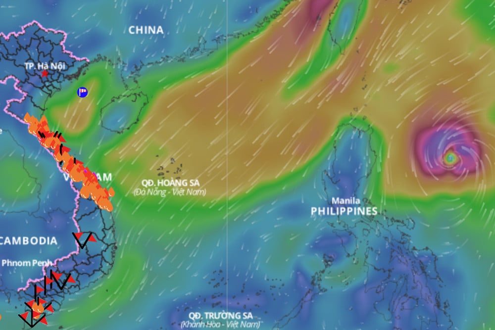
In the next 3-7 days, the cold air will continue to strengthen southward, then stabilize and gradually weaken. The low pressure trough with an axis at about 4-8 degrees north latitude will weaken and move southward. The northeast wind will gradually strengthen over the southern sea. Above, the subtropical high pressure will cross the North Central region. Around November 8, storm Yinxing is likely to enter the northeast of the East Sea.
According to experts, Typhoon Yinxing is forecast to enter the East Sea and become the seventh typhoon of 2024. Due to the influence of Typhoon Yinxing, the humid clouds in the East Sea will be drawn to the center of the storm, so the Central region will not have rain from November 9-12. However, it is not yet possible to confirm whether Typhoon No. 7 will make landfall or not.

Heavy rain in Central Vietnam likely to end sooner than forecast

Hanoi weather for the next 3 days: Welcoming strong cold air, cold weather with showers
Central region faces peak flood season, low pressure likely to appear in East Sea
Source: https://vietnamnet.vn/mien-trung-mua-lon-cao-diem-2-ngay-toi-bien-dong-kha-nang-don-bao-yinxing-2338891.html
![[Photo] Binh Thuan organizes many special festivals on the occasion of April 30 and May 1](https://vphoto.vietnam.vn/thumb/1200x675/vietnam/resource/IMAGE/2025/5/1/5180af1d979642468ef6a3a9755d8d51)


![[Photo] Ha Giang: Many key projects under construction during the holiday season](https://vphoto.vietnam.vn/thumb/1200x675/vietnam/resource/IMAGE/2025/5/1/8b8d87a9bd9b4d279bf5c1f71c030dec)


![[Photo] Feast your eyes on images of parades and marching groups seen from above](https://vphoto.vietnam.vn/thumb/1200x675/vietnam/resource/IMAGE/2025/4/30/3525302266124e69819126aa93c41092)


Comment (0)