

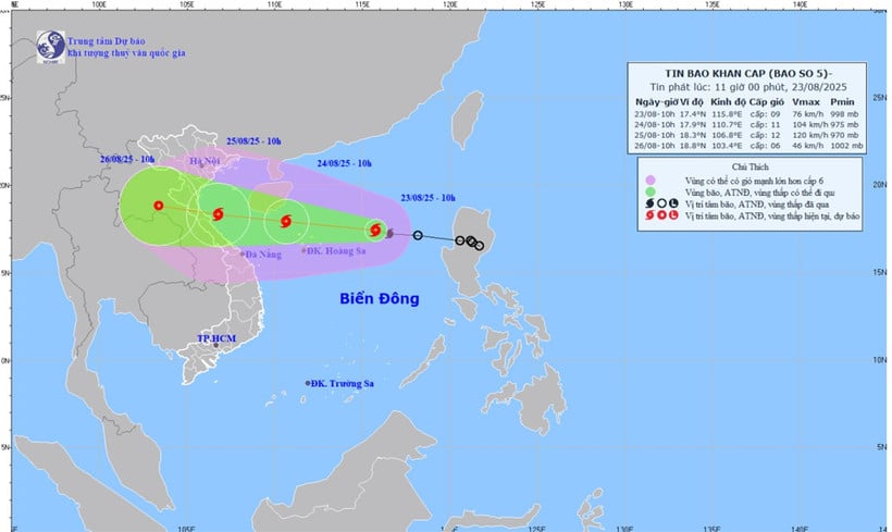
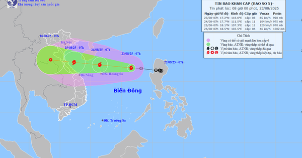
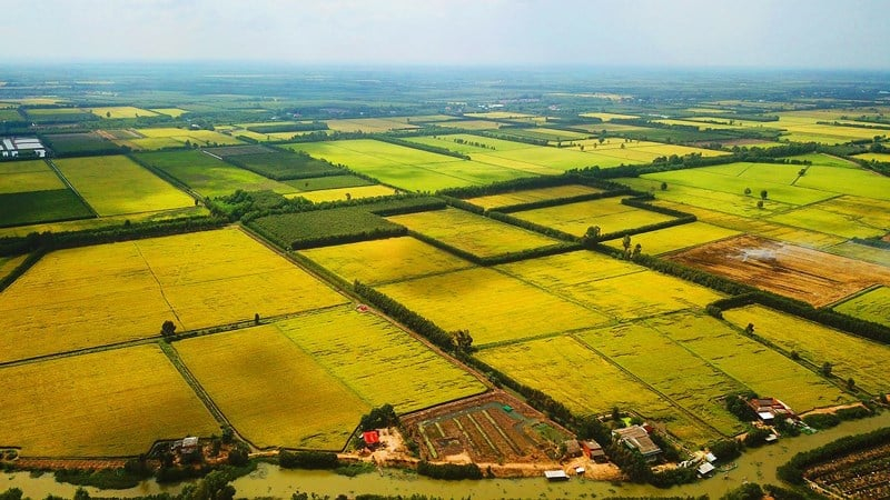
At 7:00 a.m., the center of the storm was determined to be at approximately 17.2 degrees North latitude and 116.6 degrees East longitude, approximately 620 km East-Northeast of Hoang Sa archipelago and more than 1,300 km from Dong Thap province. The strongest wind near the center of the storm reached level 11, gusting to level 14, moving in a West-Northwest direction at a speed of 20 km/hour.
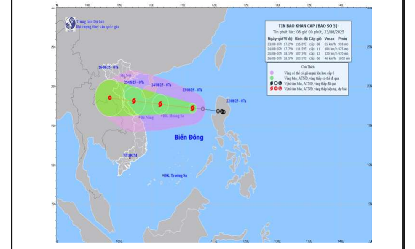 |
| Map of forecast intensity and location of storm No. 5 at 7:00 a.m. on August 23, 2025. |
In the next 24 hours, the storm will move in the West Northwest direction, at a speed of about 20 - 25 km/h and continue to strengthen. At 7:00 a.m. on August 24, the center of the storm will be at about 17.7 degrees North latitude, 111.5 degrees East longitude, in the sea northwest of Hoang Sa island, with winds near the center at level 10 - 11, gusting to level 14.
In the next 24 to 48 hours, the storm will move in a West-Northwest direction, at a speed of about 20 km/h. At 7:00 a.m. on August 25, the center of the storm was at about 18.1 degrees North latitude, 107.3 degrees East longitude, over the sea from Thanh Hoa to Hue, with winds near the center at level 11-12, gusting to level 15.
During the next 48 to 72 hours, the storm will move west-northwest at a speed of about 15 km/h and gradually weaken into a tropical depression. At 7:00 a.m. on August 26, the center of the storm was at about 18.5 degrees north latitude, 103.5 degrees east longitude, on the mainland of Central Laos, with winds near the center at level 6, gusting to level 8.
In the North East Sea area (including Hoang Sa special zone), there are strong winds of level 8 - 9, near the storm center, level 10 - 11, gusts of level 14, waves 4 - 6 m high, rough seas.
From the afternoon of August 23, the sea area from Thanh Hoa to Hue (including Con Co and Hon Ngu special zones) will have winds gradually increasing to level 6 - 8, then increasing to level 9 - 10, near the storm's eye level 11 - 12, gusting to level 15; waves 4 - 6 m high, near the eye 6 - 8 m, rough seas. From the night of August 23, the sea area of Bac Bo Gulf (including Bach Long Vi island) will have winds gradually increasing to level 6 - 7, gusting to level 9, waves 2 - 3 m high, rough seas.
Sea area from Lam Dong to Ca Mau (including Go Cong Dong - Tan Phu Dong sea area), Southwest wind level 4, gust level 5, wave height 1 - 2.5 m.
Ships operating in the above mentioned dangerous areas are likely to be affected by strong winds and large waves.
In the mainland of Dong Thap and the South, the weather in the coming days is forecast to be cloudy with scattered showers, locally moderate to heavy rain with thunderstorms. During thunderstorms, people need to be on guard against dangerous phenomena such as tornadoes, lightning and strong gusts of wind.
CT
Source: https://baoapbac.vn/xa-hoi/202508/dong-thap-mua-rao-rai-rac-cuc-bo-co-noi-mua-to-kem-dong-do-anh-huong-bao-so-5-1048520/


![[Photo] General Secretary To Lam attends the 80th Anniversary of the Cultural Sector's Traditional Day](https://vstatic.vietnam.vn/vietnam/resource/IMAGE/2025/8/23/9f771126e94049ff97692935fa5533ec)


Comment (0)