

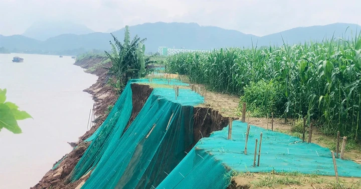
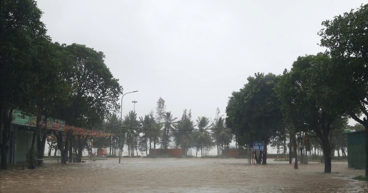
Heavy rain caused water to rise, flooding roads and underground rivers in communes in the northern border area of Quang Tri province.
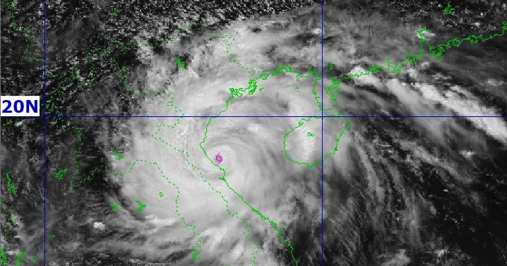
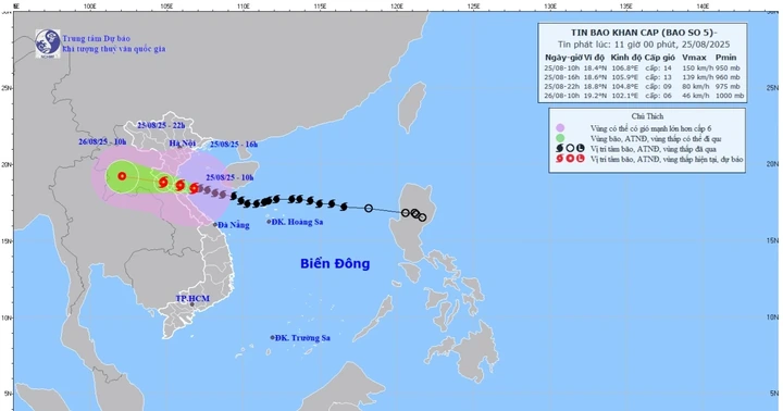
According to the National Center for Hydro-Meteorological Forecasting, at 6:00 p.m. on August 25, the center of storm No. 5 was located at about 18.4 degrees North latitude; 105.8 degrees East longitude, on the mainland of Nghe An - Ha Tinh area. The strongest wind speed is level 11 (103-117 km/h), gusting to level 13.
Forecast in the next 3 hours, the storm moves in the West Northwest direction, speed about 10-15km/h
From 5:30 p.m. to 10:30 p.m. on August 25, due to the influence of storm No. 5, the areas of Phu Tho, Quang Ninh provinces and from Thanh Hoa to Quang Tri continued to have rain with common accumulated rainfall as follows: Phu Tho, Quang Ninh had rain from 30-60mm, some places over 100mm; Thanh Hoa, Nghe An and Ha Tinh had rain from 80-120mm, some places over 200mm; Quang Tri had rain from 20-40mm, some places over 70mm.
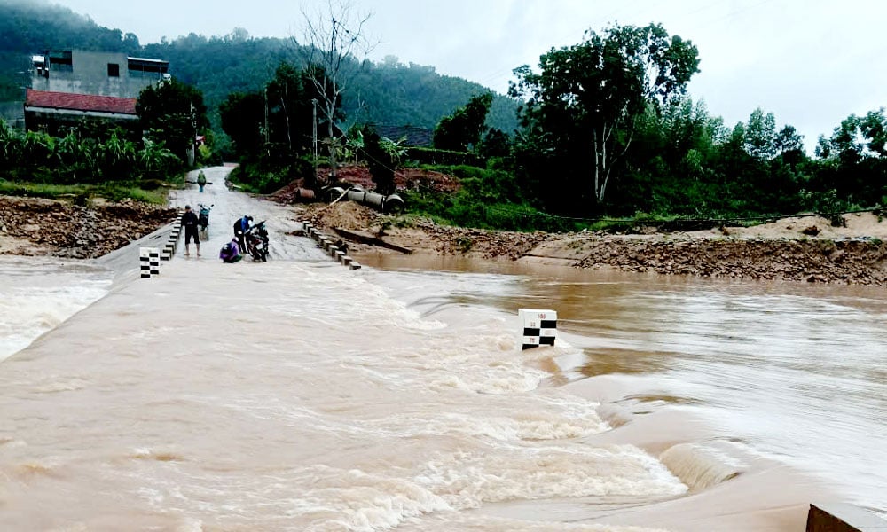
Warning of the risk of flash floods on small rivers and streams, landslides on steep slopes in many communes/wards: An Binh, Dai Dong, Mai Ha, Van Son, Yen Thuy, Yen Tri; Bao La, Cao Phong, Cao Son, Da Bac, Dung Tien, Huong Can, Lac Luong, Lac Son, Lac Thuy, Luong Son, Mai Chau, Muong Bi, Muong Hoa, Muong Thang, Ngoc Son, Hoa Binh, Ky Son, Tan Hoa, Thong Nhat, Pa Co, Quy Duc, Quyet Thang, Tan Lac, Tan Mai, Tan Pheo, Thinh Minh, Thung Nai, Thuong Coc, Tien Phong, Toan Thang, Yen Phu, Yen Son; An Nghia, Ban Nguyen, Binh Tuyen, Binh Xuyen, Cao Duong, Cu Dong, Dao Xa, Duc Nhan, Hoang An, Hoi Thinh, Hop Kim, Kha Cuu, Kim Boi, Lien Hoa, Lien Son, Muong Dong, Muong Vang, Nat Son, Nhan Nghia, Vinh Yen, Xuan Hoa, Phung Nguyen, Son Dong, Tam Dao, Tam Duong, Tam Nong, Te Lo, Thanh Thuy, Tho Tang, Tho Van, Tien Lu, Tu Vu, Van Mieu, Vinh An, Vinh Hung, Vinh Phu, Vinh Thanh, Vinh Tuong (Phu Tho province).
In Quang Ninh province, there are communes and wards: Ky Thuong, Cao Xanh, Mong Duong, Thong Nhat; Van Don Special Zone, Hai Hoa, Hai Lang, Luong Minh, An Sinh, Bai Chay, Binh Khe, Cam Pha, Cua Ong, Dong Mai, Ha Lam, Ha Long, Ha Tu, Hoang Que, Hoanh Bo, Hong Gai, Quang Hanh, Tuan Chau, Uong Bi, Vang Danh, Viet Hung, Yen Tu, Quang La.
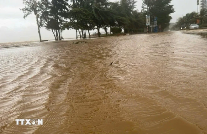
High tide overflowed the dike onto Ho Xuan Huong street, Sam Son tourist area (Thanh Hoa).
For Thanh Hoa province, the communes and wards are: Cam Thach, Cam Thuy, Cam Tu, Co Lung, Dien Lu, Dong Luong, Hoa Quy, Kien Tho, Linh Son, Luan Thanh, Luong Son, Mau Lam, Minh Son, Ngoc Lien, Nhu Thanh, Nhu Xuan, Quy Luong, Thach Lap, Thach Quang, Thang Loc, Thanh Phong, Thanh Quan, Thanh Vinh, Thuong Xuan, Van Nho, Van Phu, Van Xuan, Xuan Binh, Xuan Chinh, Yen Thang; Ba Thuoc, Bat Mot, Cam Tan, Cam Van, Cong Chinh, Dien Quang, Giao An, Hien Kiet, Hoi Xuan, Hop Tien, Muong Ly, Muong Min, Nam Xuan, Ngoc Lac, Ngoc Trao, Nguyet An, Phu Le, Phu Xuan, Pu Luong, Quan Son, Son Dien, Tam Lu, Tam Thanh, Tan Thanh, Tay Do, Thach Binh, Thanh Ky, Thien Phu, Thiet Ong, Thuong Ninh, Trung Ha, Trung Ly, Trung Son, Trung Thanh, Truong Lam, Van Du, Xuan Du, Xuan Thai, Xuan Tin, Yen Khuong, Yen Nhan, Yen Phu, Yen Tho; Muong Chanh, Muong Lat, Na Meo, Nhi Son, Pu Nhi, Quang Chieu, Son Thuy, Tam Chung.
Communes and wards at risk of flash floods and landslides in Nghe An province include Anh Son, Chau Hong, Chau Loc, Dong Hieu, Giai Xuan, Hanh Lam, Hung Chan, Kim Bang, Minh Hop, Muong Chong, Muong Ham, Nghia Dong, Nghia Hanh, Nghia Hung, Nghia Khanh, Tay Hieu, Thai Hoa, Quy Chau, Quy Hop, Tam Dong, Tam Hop, Tan An, Tan Ky, Tan Phu, Thanh Binh Tho, Thong Thu, Tien Dong, Tien Phong, Xuan Lam, Yen Xuan; Anh Son Dong, Bich Hao, Binh Chuan, Cam Phuc, Cat Ngan, Chau Binh, Chau Tien, Con Cuong, Dai Dong, Hoa Quan, Mau Thach, Mon Son, Muong Quang, Nghia Dan, Nhan Hoa, Que Phong, Son Lam, Thuan Trung, Van An, Vinh Tuong; Bac Ly, Chau Khe, Chieu Luu, Huoi Tu, Huu Khuong, Huu Kiem, Keng Du, Luong Minh, Muong Long, Muong Tip, Muong Xen, My Ly, Na Loi, Na Ngoi, Nam Can, Nga My, Nhon Mai, Tam Quang, Tam Thai, Tri Le, Tuong Duong, Yen Hoa, Yen Na.
Along with that, in Ha Tinh province, there are communes and wards: Cam Due, Cam Hung, Cam Lac, Cam Trung, Cam Xuyen, Can Loc, Co Dam, Duc Dong, Duc Quang, Ha Linh, Hong Loc, Huong Binh, Huong Do, Huong Khe, Huong Pho, Huong Xuan, Ky Anh, Ky Hoa, Ky Khang, Ky Lac, Ky Thuong, Ky Van, Ky Xuan, Mai Hoa, Mai Phu, Nghi Xuan, Bac Hong Linh, Hai Ninh, Hoanh Son, Nam Hong Linh, Song Tri, Vung Ang, Phuc Trach, Son Kim 2, Son Tay, Son Tien, Thach Khe, Thach Xuan, Thuong Duc, Truong Luu, Tung Loc, Vu Quang; Duc Minh, Duc Tho, Huong Son, Kim Hoa, Son Giang, Son Hong, Tu My; Son Kim 1.
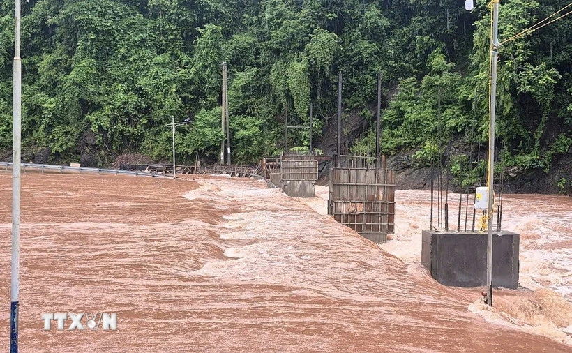
In addition, in Quang Tri province, there are communes and wards: Bac Trach, Bo Trach, Dan Hoa, Dong Le, Dong Trach, Hoa Trach, Hoan Lao, Kim Dien, Kim Phu, Minh Hoa, Nam Ba Don, Nam Gianh, Phong Nha, Phu Trach, Quang Ninh, Quang Trach, Tan Gianh, Tan Thanh, Trung Thuan, Tuyen Binh, Tuyen Hoa, Tuyen Lam, Tuyen Phu, Tuyen Son; Nam Trach, Dong Son, Truong Ninh, Truong Son; Huong Phung, Kim Ngan, Le Ninh, Truong Phu.
Warning level of natural disaster risk due to flash floods, landslides, land subsidence due to heavy rain or water flow level 1; Ha Tinh province level 2.
Flash floods and landslides can have very negative impacts on the environment, threaten people's lives; cause local traffic congestion, affect the movement of vehicles; destroy civil and economic works, causing damage to production and socio-economic activities.
The hydrometeorological agency recommends that local authorities pay attention to reviewing bottlenecks and vulnerable locations in the area to take preventive and response measures.
From 0:00 to 16:00 on August 25, the areas of Phu Tho, Quang Ninh provinces and from Thanh Hoa to Quang Tri had moderate rain, heavy rain to very heavy rain such as: Van Mai (Phu Tho) 135.2mm; Phong Coc (Quang Ninh) 125.2mm; Bai Thuong (Thanh Hoa) 185.4mm; Yen Thuong (Nghe An) 172.4mm; Thuong Tuy Lake (Ha Tinh) 542.6mm, Song Rac Lake (Ha Tinh) 476.8mm; Song Thai Lake (Quang Tri) 328.8mm, Vuc Tron Lake (Quang Tri) 307mm...
Soil moisture models show that some areas in the above provinces are close to saturation (over 85%) or have reached saturation.
Source vietnamplus.vn
Source: https://baophutho.vn/bao-so-5-da-vao-dat-lien-khu-vuc-nghe-an-ha-tinh-gio-giat-cap-13-238530.htm
![[Photo] General Secretary To Lam attends the 80th anniversary of Vietnam's diplomacy](https://vstatic.vietnam.vn/vietnam/resource/IMAGE/2025/8/25/3dc715efdbf74937b6fe8072bac5cb30)


Comment (0)