

How many heat waves will there be in June?
Commenting on weather patterns in June 2024, Deputy Head of Climate Forecast Department, National Center for Hydro-Meteorological Forecasting Tran Thi Chuc said that in June, the average temperature across the country was generally 0.5-1 degree Celsius higher than the average of many years, with some places in the Central Central and South Central regions being over 1 degree Celsius higher than the average of many years in the same period.

June may also see 1-2 severe heat waves.
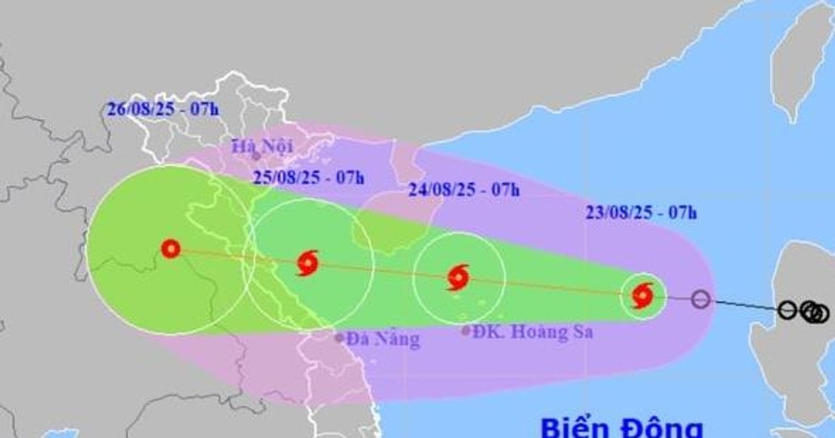
In the first 10 days of June, there is little chance of widespread heat waves in the regions. After that, heat waves are likely to increase in the provinces and cities in the Northern and Central regions. During the month, there is a possibility of 1-2 storms and tropical depressions in the East Sea.
June may also see 1-2 severe heat waves. In July and August 2024, heat waves are likely to appear more frequently than the average of many years, with about 4-6 heat waves and severe heat waves.
The peak heat in some places reaches 40 degrees Celsius, causing great impacts on people's health and lives. According to the Ministry of Health , hot weather makes the body sweat a lot, causing dehydration and electrolyte loss, especially in children, which can easily lead to metabolic disorders.
Hot weather makes food easily spoiled, easily infected with fungi and bacteria, which causes digestive diseases. In addition, when fighting the heat by turning on a strong fan directly on the body or setting the air conditioner temperature too low, it can cause colds, pneumonia, etc.
Regarding the rain situation, Ms. Tran Thi Chuc said that the total rainfall in the North and North Central regions is 10-30% higher than the average of many years, other regions are generally approximately the same as the average of many years in the same period. The North and North Central regions will have many rainy days, especially in the first 10 days of the month, the above areas are likely to have moderate to heavy rain over a wide area. In the Central Highlands and the South, the Southwest monsoon tends to become stronger, so the rain is likely to increase in both area and amount.
According to the meteorological agency, in May, there were many thunderstorms, tornadoes and hailstorms nationwide, most concentrated in the Northern and Central provinces and some places in the Central Highlands, causing significant damage. In May, in the Northern Delta and Central regions, there was a heat wave, with some places experiencing severe heat from May 26-30; in which, the Thanh Hoa to Ninh Thuan region experienced severe heat, with some places experiencing especially severe heat with the highest daily temperature commonly ranging from 36-39 degrees Celsius, with some places above 40 degrees Celsius. Many meteorological stations nationwide recorded the highest daily temperature value exceeding historical values.
What is unusual about this year's storm season?
According to the forecast of the General Department of Hydrometeorology, the El Nino phenomenon (warm phase) will last until mid-2024 and peak, so 2024 could be the 10th consecutive year with the highest average global temperature and natural disasters will be more unusual. Warning of water shortage risk in the Northern, Central Highlands and Southern regions in the first half of the year, in the Central region in June, July and August.
The El Nino phenomenon will turn neutral in the middle of the year, followed by the La Nina phenomenon, so the activity of storms and tropical depressions will likely be more concentrated in the second half of the year. In particular, there will be more storms and tropical depressions forming in the East Sea, with the forecast that the storm structure in the East Sea will account for 1/3 of the total number of storms.

During the month, there is a possibility of 1-2 storms and tropical depressions appearing in the East Sea.
That means storm prevention and control will have to be done faster and more urgently because storms in the East Sea will impact the mainland very quickly. Along with that, thunderstorms and short-term heavy rains appear more frequently, causing landslides in mountainous areas and urban flooding.
Faced with the above dangerous weather phenomena, hydrometeorological experts recommend that people regularly monitor forecast and warning information on the website of the National Center for Hydro-Meteorological Forecasting at nchmf.gov.vn, provincial, municipal and regional hydrometeorological stations; regularly update the latest hydrometeorological forecast information on the official mass media of the Central and local levels to proactively respond.
The government and relevant agencies need to promptly provide disaster forecast information to the people, mobilize, propagate and implement an absolute ban on people's activities in areas at high risk of thunderstorms, tornadoes, lightning, hail, strong winds, big waves, etc. People need to strictly follow the instructions on disaster response and prevention from local authorities.
Source: https://danviet.vn/thang-6-se-xuat-hien-bao-nhieu-dot-nang-nong-bao-nhieu-con-bao--ap-thap-nhiet-doi-tren-bien-dong-20240602172736068.htm

![[Photo] Prime Minister Pham Minh Chinh chairs the meeting of the Government Party Committee Standing Committee](https://vstatic.vietnam.vn/vietnam/resource/IMAGE/2025/8/23/8e94aa3d26424d1ab1528c3e4bbacc45)


![[Photo] General Secretary To Lam attends the 80th Anniversary of the Cultural Sector's Traditional Day](https://vstatic.vietnam.vn/vietnam/resource/IMAGE/2025/8/23/7a88e6b58502490aa153adf8f0eec2b2)


Comment (0)