

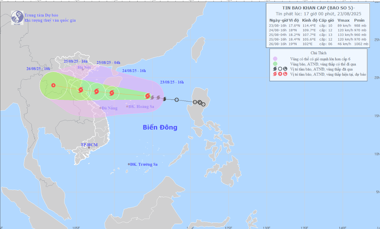
Forecast map of the trajectory and intensity of storm No. 5 released at 5:00 p.m. on August 23, 2025. Photo: nchmf
At 4pm on August 24, the storm is forecast to move west-northwest at a speed of 20-25km/h and continue to strengthen in the waters south of Hainan Island (China). Wind gusts of level 12, up to level 14.
Forecast until 4:00 a.m. on August 25, the storm will move in the West Northwest direction, speed about 15-20km/h, on the sea from Thanh Hoa to Quang Tri , wind gusts level 12-13, gust 15.
At 4:00 p.m. on August 25, the storm moved in a West-Northwest direction, at a speed of about 15-20km/h, on land from Thanh Hoa to Northern Quang Tri, with gusts of level 11-12, gusts of level 14.
At 4:00 p.m. on August 26, the storm moved in a West Northwest direction, 15-20 km/h and gradually weakened into a tropical depression.
North East Sea area (including Hoang Sa special zone): Strong winds of level 8-9, near the storm center of level 11-12, gusting to level 14. Waves 4.0-6.0m high. Rough seas.
From noon and afternoon of August 24, the sea area from Thanh Hoa to Hue (including Con Co, Hon Ngu):
Winds gradually increase to level 6–8, then increase to level 9–10, near the center of the storm level 11–13, gusting to level 15. Waves 4.0–6.0m high, near the center 7.0–9.0m. The sea is very rough.
From the afternoon of August 24, the North of Bac Bo Gulf (including the special zones: Cat Hai, Co To, Van Don): Winds gradually increase to level 6-7, gusting to level 9; in the South of the North of Bac Bo Gulf (including Bach Long Vi): Strong winds of level 8, gusting to level 10. Waves 2.0-4.0m high. Rough seas.
Coastal areas from Ninh Binh to Northern Quang Tri: storm surge 0.5–1.2m high.
Forecast water level: Sam Son 3.2–3.6m; Hon Ngu 3.3–3.8m; Vung Ang 2.2–2.8m; Cua Gianh 1.5–2.0m.
The weather at sea and in coastal areas during storms is extremely dangerous and unsafe for any vehicles or structures operating in the danger zone such as: cruise ships, passenger ships, cargo ships, cages, rafts, aquaculture areas, dykes, embankments, coastal routes. Vehicles are at high risk of capsizing, destruction, and flooding due to strong winds, large waves, and rising sea levels.
Strong winds on land:
From the night of August 24, inland areas of Thanh Hoa - Quang Tri: Winds will gradually increase to level 7-9, near the storm center level 10-12, gusting to level 14-15; coastal areas of provinces from Quang Ninh to Ninh Binh will gradually increase to level 6-7, gusting to level 8.
Heavy rain on land:
From the night of August 24 to the end of August 26: The Northern Delta, Southern Phu Tho and Thanh Hoa - Hue are likely to experience widespread heavy rain, with rainfall ranging from 100-150mm, locally >250mm. Particularly, Thanh Hoa - Northern Quang Tri will experience heavy to very heavy rain, with rainfall ranging from 200-400mm, in some places >700mm. Risk of heavy rain >200mm/3 hours.
LP
Source: https://baothanhhoa.vn/bao-so-5-khi-di-vao-dat-lien-khu-vuc-cac-tinh-mien-trung-giat-cap-15-mua-lon-dien-rong-259170.htm
![[Photo] Prime Minister Pham Minh Chinh chairs the meeting of the Government Party Committee Standing Committee](https://vstatic.vietnam.vn/vietnam/resource/IMAGE/2025/8/23/8e94aa3d26424d1ab1528c3e4bbacc45)


![[Photo] General Secretary To Lam attends the 80th Anniversary of the Cultural Sector's Traditional Day](https://vstatic.vietnam.vn/vietnam/resource/IMAGE/2025/8/23/7a88e6b58502490aa153adf8f0eec2b2)


Comment (0)