

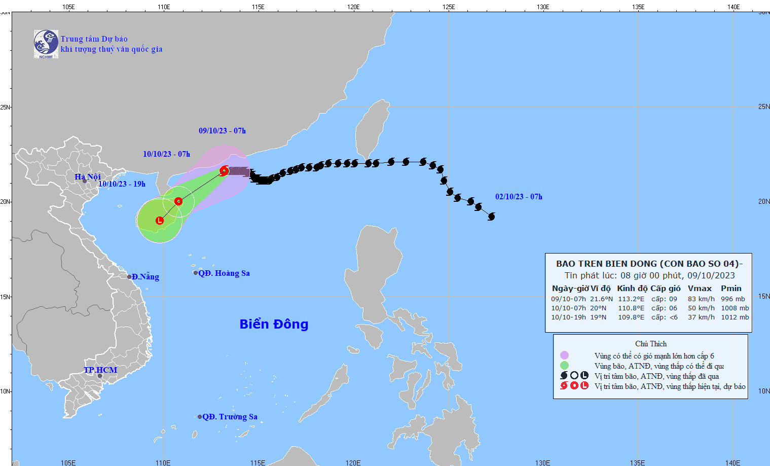
At 7:00 a.m. on October 9, the center of storm No. 4 was at about 21.6 degrees North latitude; 113.2 degrees East longitude, in the sea south of Guangdong province (China). The strongest wind near the center of the storm was level 9 (75-88 km/h), gusting to level 12, moving slowly westward at a speed of about 5 km/h.
Forecast by 7:00 a.m. on October 10, storm No. 4 in the northeastern area of Hainan Island (China), the strongest wind near the storm center is level 6-7, gusting to level 9, moving southwest, speed 10-15km/h and weakening into a tropical depression.
At 7:00 p.m. on October 10, storm No. 4 in the Hainan island area, with the strongest wind near the storm center below level 6, continued to move southwest, maintaining a speed of 10-15 km/h and weakening into a low pressure area.
According to the Hydrometeorological Agency, in the next 24 hours, the northwest sea of the North East Sea will have strong winds of level 6-7, near the storm center strong winds of level 8-9, gusting to level 12; very rough seas. In addition, due to the influence of strengthening cold air, from early morning on October 10, the sea in the Gulf of Tonkin will have strong northeast winds of level 6, gusting to level 8; rough seas.
In the North East Sea, waves are 2-3m high, and near the storm center, waves are 3-5m high. Since the morning of October 10, in the Gulf of Tonkin, waves are 2-3m high. All ships operating in these areas are affected by strong winds and large waves.
Source
![[Photo] General Secretary To Lam attends the 80th Anniversary of the Cultural Sector's Traditional Day](https://vstatic.vietnam.vn/vietnam/resource/IMAGE/2025/8/23/7a88e6b58502490aa153adf8f0eec2b2)

![[Photo] Prime Minister Pham Minh Chinh chairs the meeting of the Government Party Committee Standing Committee](https://vstatic.vietnam.vn/vietnam/resource/IMAGE/2025/8/23/8e94aa3d26424d1ab1528c3e4bbacc45)


Comment (0)