

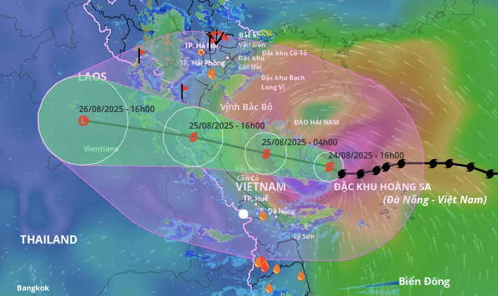
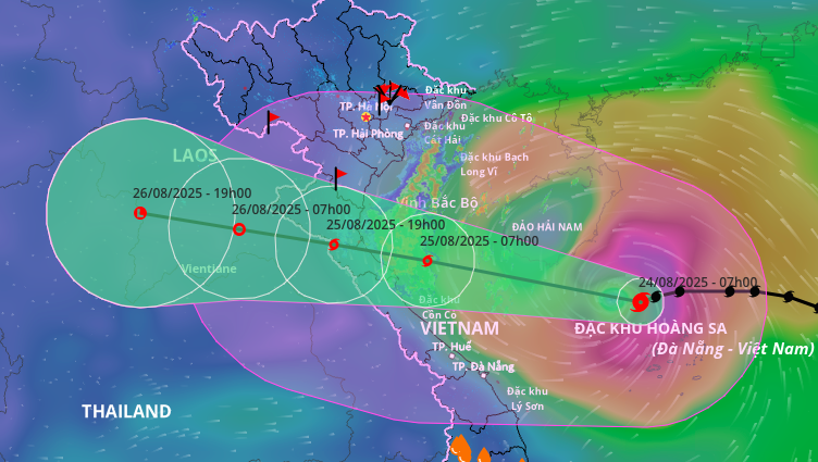
It is forecasted that tomorrow evening (August 25), the storm will make landfall in the provinces from Thanh Hoa to Quang Tri .
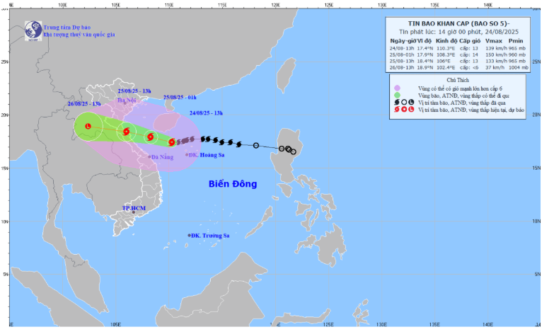
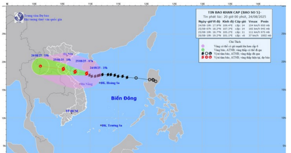
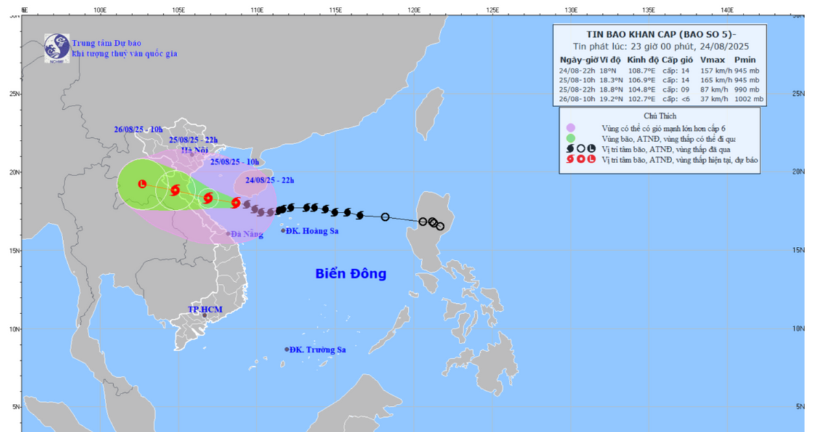
Specifically, at 4:00 p.m. on August 24, the center of storm No. 5 was at approximately 17.6 degrees North latitude; 109.9 degrees East longitude, approximately 470km from the mainland of Nghe An province and 450km from Ha Tinh province to the East Southeast. The strongest wind near the center of the storm was at level 13-14 (134-166km/h), gusting to level 16.
The storm is moving west at a speed of about 20km/h and is forecast to strengthen before approaching land.
Forecast in the next 24 to 48 hours, the storm's developments are very complicated:
- At 4:00 a.m. on August 25: The center of the storm is located at approximately 18.0 degrees North latitude; 107.9 degrees East longitude, right on the southern sea of the Gulf of Tonkin. The storm is approximately 240km from Nghe An and 210km east-southeast of Ha Tinh. The strongest winds remain at level 13-14, gusting to level 16.
- At 4:00 p.m. on August 25: The center of the storm is located at approximately 18.5 degrees North latitude; 105.6 degrees East longitude, on the mainland of the provinces from Thanh Hoa to Quang Tri. The strongest wind speed has decreased to level 11-12, gusting to level 14.
. - By 4:00 p.m. on August 26: The storm will move deep inland, into Central Laos and weaken into a low pressure area with winds below level 6.
The disaster risk level is raised to level 4 (very high) in coastal areas from Thanh Hoa to Quang Tri and on land in these provinces when the storm makes landfall.
Storm impact warning
At sea: Rough seas
From this afternoon and tonight (August 24), the sea area of Nghe An province (including Hon Ngu island) will have winds gradually increasing to level 7-9, then increasing to level 10-11, the area near the storm center will have strong winds of level 12-14, gusting to level 16. Waves will be 5.0-7.0m high, near the storm center waves will be 8.0-10.0m high. The sea will be very rough.
Coastal areas of Nghe An province need to be on guard against storm surges of 0.5-1.5m high. There is a high risk of flooding in low-lying coastal areas and river mouths due to big waves and surges in the afternoon and evening of August 25.
The meteorological agency warns that the weather at sea and in coastal areas during the storm is extremely dangerous and unsafe for any vehicles or structures.
Boats, rafts, and aquaculture areas are at high risk of capsizing, destruction, and flooding.
On land: Level 15 wind gusts with extremely heavy rain
From tonight (August 24), on the mainland of Nghe An province, the wind will gradually increase to level 8-10, the area near the storm's center may be level 11-13, gusting to level 14-15 .
Regarding heavy rain, from the night of August 24 to the end of August 26, Nghe An province is likely to experience a period of heavy to very heavy rain. Total rainfall is generally from 200-400mm, locally over 600mm. Warning of the risk of very heavy rain (over 150-200mm in 3 hours), which can cause flash floods, landslides in mountainous areas and deep flooding in urban areas and low-lying areas.
Nghe An Newspaper and PTTH will continue to update the latest information.
Source: https://baonghean.vn/tin-bao-khan-cap-bao-so-5-giat-cap-16-tien-thang-vao-dat-lien-cac-tinh-tu-thanh-hoa-den-quang-tri-10305112.html


Comment (0)