

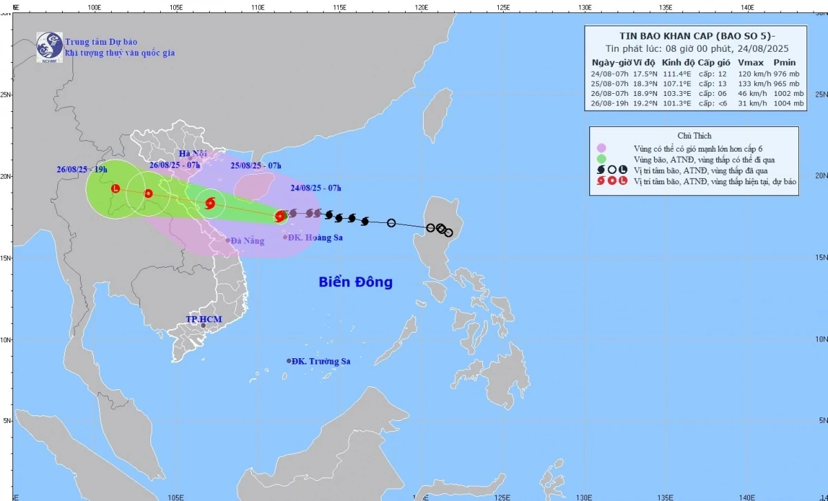
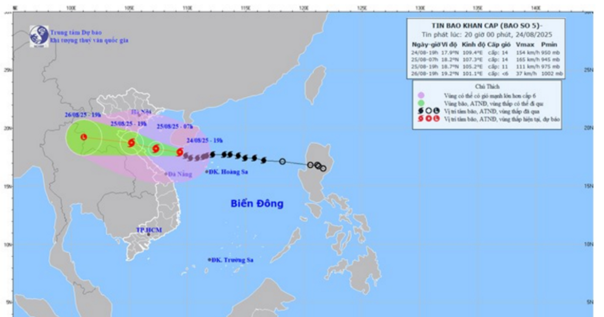
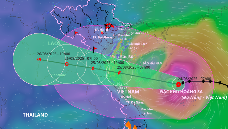
According to the National Center for Hydro-Meteorological Forecasting, the strongest wind near the center of storm No. 5 is level 12 (118-133km/h), gusting to level 15; moving west at a speed of about 20km/h.
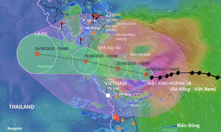
Forecast, at 7:00 a.m. on August 25, the storm will move West Northwest, at a speed of about 20km/h in the Southern Gulf of Tonkin; about 160 km from Nghe An, about 140 km east of Ha Tinh ; Level 12-13 intensity, gust level 15; and may continue to strengthen. The affected areas are the Northwest sea area of the Northern East Sea (including Hoang Sa special zone), Bac Bo Gulf, the sea area of South Quang Tri - Hue City (including Hon Ngu island, Con Co special zone).
At 7:00 a.m. on August 26, the storm moved to the West Northwest, at a speed of 15-20 km/h and gradually weakened over the Upper Laos region; Intensity decreased to level 6, gusting to level 8. Affected areas: Gulf of Tonkin, sea area of Southern Quang Tri - Hue City (including Hon Ngu Island, Con Co special zone); Coastal waters from Thanh Hoa to Quang Tri, mainland provinces from Thanh Hoa to Northern Quang Tri.
Due to the influence of storm No. 5, the western sea area of the North East Sea (including Hoang Sa special zone) has strong winds of level 8-10, the area near the storm's eye has winds of level 11-13, gusts of level 15, waves 5.0-7.0m high, the area near the storm's eye has waves of 7.0-9.0m, and the sea is very rough.
From noon and afternoon of August 24, the sea area from Thanh Hoa to Hue City (including Hon Ngu Island, Con Co Special Zone) will have winds gradually increasing to level 6-8, then increasing to level 9-10, near the storm center will have winds of level 11-13, gusting to level 15; waves 4.0-6.0m high, near the center 7.0-9.0m; the sea will be very rough. From the afternoon of August 24, the North of Bac Bo Gulf (including the special zones: Cat Hai, Co To, Van Don) will have winds gradually increasing to level 6-7, gusting to level 9; in particular, the South of the North of Bac Bo Gulf (including Bach Long Vi Special Zone) will have strong winds of level 8, gusting to level 10; waves 2.0-4.0m high; the sea will be very rough.
Coastal areas from Hai Phong to Ha Tinh have storm surges of 0.5-1.5m high. Water levels at Hon Dau are 3.3-3.8m high, at Ba Lat are 1.7-2.1m high, at Sam Son are 3.2-3.7m high, at Hon Ngu are 3.2-3.6m high, at Cua Nhuong are 2.2-2.6m high. There is a high risk of flooding in low-lying coastal areas, river mouths, and islands from Hai Phong to Ha Tinh.
Warning: The weather at sea and in coastal areas during the storm is extremely dangerous and unsafe for any vehicles or structures operating in the danger zone such as: cruise ships, passenger ships, cargo ships, cages, rafts, aquaculture areas, dykes, embankments, coastal routes. Vehicles are at high risk of capsizing, destruction, and flooding due to strong winds, large waves, and rising sea levels.
From the night of August 24, on land from Thanh Hoa to Quang Tri, winds will gradually increase to level 7-9, near the storm center, level 10-12, gusting to level 14-15; coastal areas from Quang Ninh to Ninh Binh, winds will gradually increase to level 6-7, gusting to level 8.
From the night of August 24 to the end of August 26, in the Northern Delta, South Phu Tho and from Thanh Hoa to Hue City, there is a possibility of widespread heavy rain with common rainfall of 100-150mm, locally over 250mm; in particular, the area from Thanh Hoa to North Quang Tri will have heavy to very heavy rain with common rainfall of 200-400mm, locally over 700mm. Warning of the risk of heavy rain (>200mm/3 hours).
Source vov.vn
Source: https://baophutho.vn/bao-so-5-manh-cap-13-giat-cap-15-canh-bao-nguy-hiem-tu-thanh-hoa-den-quang-tri-238449.htm


Comment (0)