

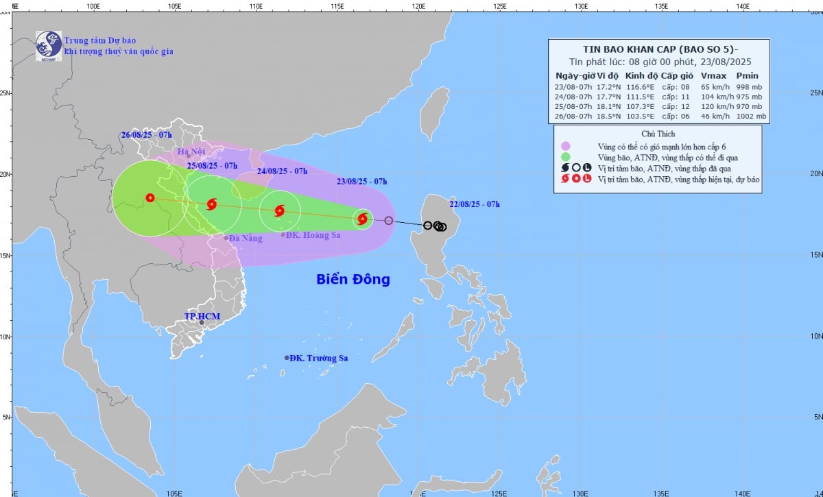
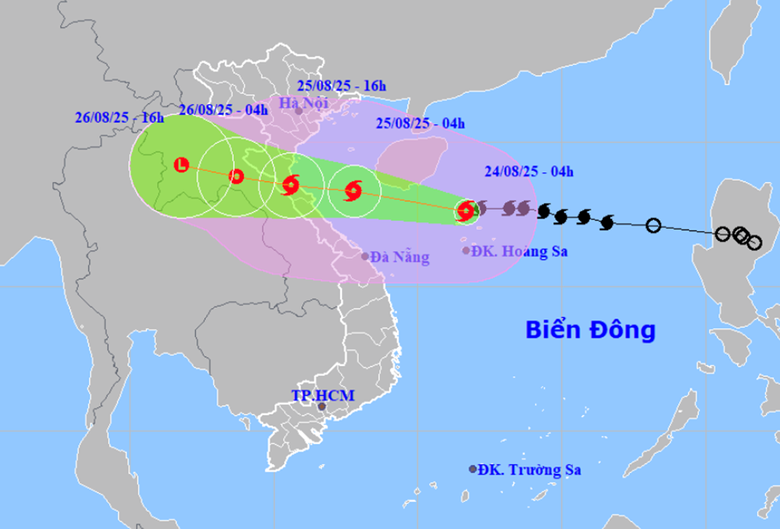
This morning (August 23), the tropical depression in the eastern sea of the northern East Sea has strengthened into a storm, storm number 5 (international name: Kajiki). Storm number 5 is moving very quickly, forecast to cause heavy rain and a wide area of influence.
According to the National Center for Hydro-Meteorological Forecasting, this morning, August 23, the tropical depression has strengthened into a storm. Storm No. 5 has the international name Kajiki.
 |
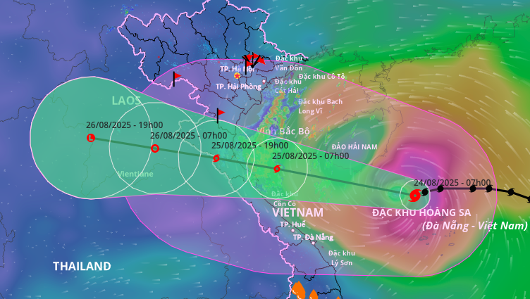
| Direction of storm No. 5 (Photo: National Center for Hydro-Meteorological Forecasting) |
At 10:00 a.m. today, the center of the storm was at approximately 17.4°N; 115.8°E, approximately 380km east-northeast of Hoang Sa. Intensity: level 8-9 (62–88km/h), gusting to level 11. Direction and speed of movement: West-Northwest, speed approximately 25km/h.
Currently, the center of the storm is about 320km east-northeast of Vietnam's Hoang Sa special zone. The storm is at level 8, gusting to level 10. It is forecasted that in the next 24 hours, the storm will move west-northwest at a speed of about 25km/h and continue to strengthen.
The area affected by storm No. 5 is the northern part of the East Sea, including the Hoang Sa special zone. It is forecasted that by August 25, storm No. 5 will affect the western part of the northern East Sea, including the Hoang Sa special zone, the Gulf of Tonkin, and the southern part of Quang Tri - Hue. By August 26, storm No. 5 will weaken into a tropical depression, affecting the Gulf of Tonkin and the southern part of Quang Tri - Hue.
According to the forecast, from the afternoon of August 24, the sea areas from Thanh Hoa to Hue will have winds gradually increasing to level 6 - 8, then increasing to level 9 - 10, the area near the storm's center will have winds gradually increasing to level 11 - 12, gusting to level 15. From the night of August 24, the sea area of Bac Bo Gulf (including Bach Long Vi) will have winds gradually increasing to level 6 - 7, gusting to level 9, rough seas.
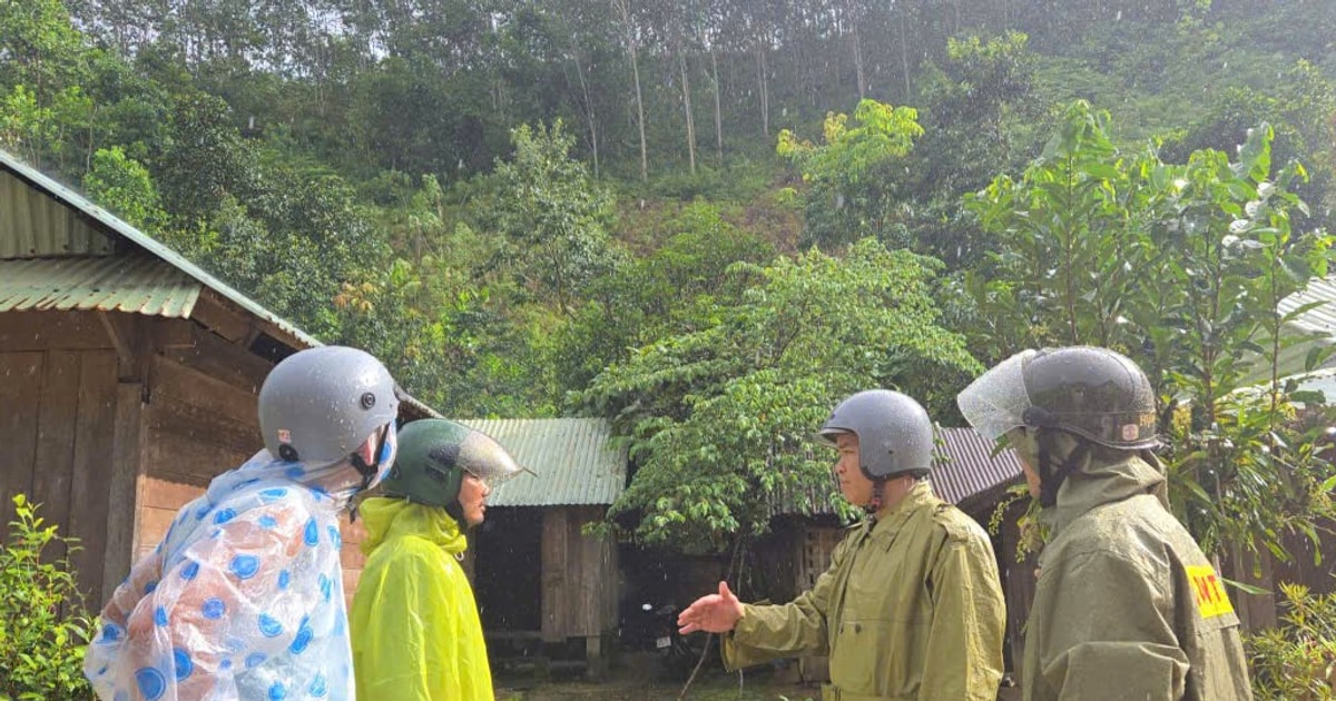
From the night of August 24 to the end of August 26, the Northern Delta and Thanh Hoa - Hue will have widespread heavy rain. Thanh Hoa - Quang Tri will have heavy to very heavy rain.
From August 25 to 26, Hanoi and Da Nang will have moderate to heavy rain and thunderstorms. Ho Chi Minh City will have rain, showers and thunderstorms in the late afternoon and evening. During thunderstorms, be on guard against tornadoes and strong gusts of wind.
Forecast of storm impact: The North East Sea area (including Hoang Sa special zone) has strong winds of level 8-9, near the storm center level 10-11, gusting to level 14. Waves are 4.0-6.0m high. The sea is very rough.
From noon and afternoon of August 24, the sea area from Thanh Hoa to Hue (including Con Co, Hon Ngu): Winds will gradually increase to level 6-8, then increase to level 9-10, near the storm center level 11-12, gusting to level 15. Waves are 4.0-6.0m high, near the center 6.0-8.0m. The sea is very rough.
From the afternoon of August 24, the sea area of the Northern Gulf of Tonkin (including Bach Long Vi): Winds will gradually increase to level 6-7, gusting to level 9. Waves will be 2.0-4.0m high. Rough seas.
Coastal areas from Thanh Hoa to Quang Tri: storm surge is 0.5–1.0 m high.
Forecast water level: Sam Son 3.2–3.6m; Hon Ngu 3.3–3.7m; Vung Ang 3.1–3.4m; Cua Gianh 1.7–2.0m.
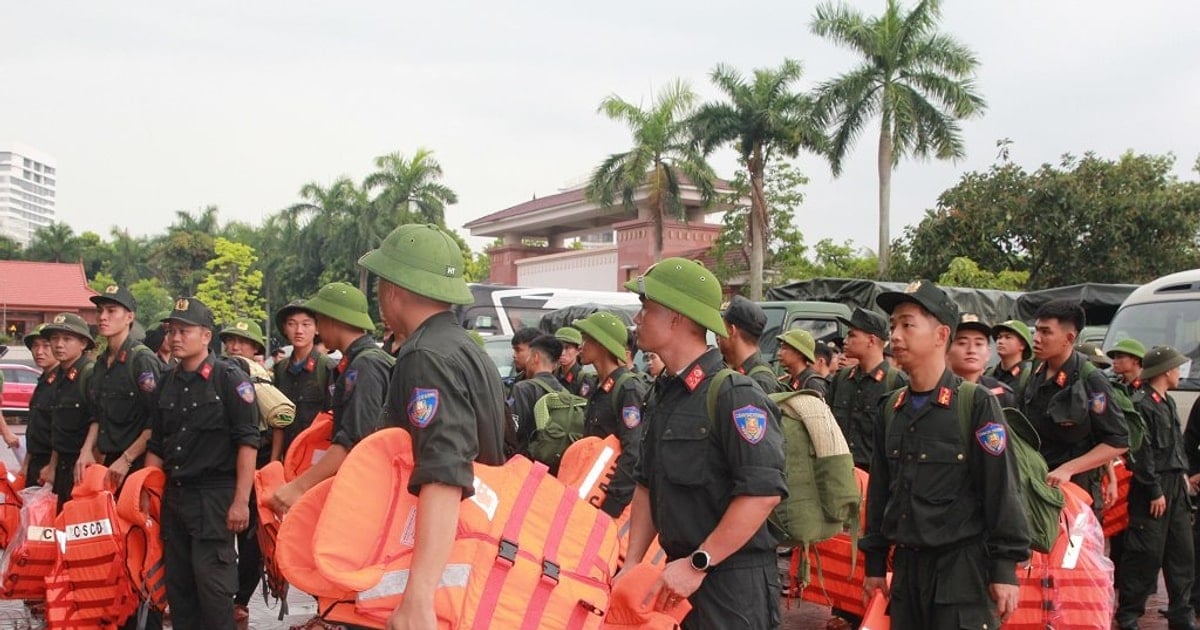
Warning: The weather at sea and in coastal areas during the storm is extremely dangerous and unsafe for any vehicles or structures operating in the danger zone such as: cruise ships, passenger ships, cargo ships, cages, rafts, aquaculture areas, dykes, embankments, coastal routes. Vehicles are at high risk of capsizing, destruction, and flooding due to strong winds, large waves, and rising sea levels.
From the night of August 24, in the mainland area of Thanh Hoa - Quang Tri: Winds will gradually increase to level 7-9, near the storm center level 10-12, gusting to level 13-15.
From the night of August 24 to the end of August 26: The Northern Delta, South Phu Tho and Thanh Hoa - Hue will have widespread heavy rain, with common rainfall of 100-150mm, locally >250mm.
Thanh Hoa - Quang Tri has heavy to very heavy rain, common rainfall 150-300mm, some places >600mm. Risk of heavy rain >200mm/3h.
August 25-26: Hanoi and Da Nang have moderate to heavy rain and thunderstorms; Ho Chi Minh City has rain, showers and thunderstorms in the late afternoon and evening. During thunderstorms, beware of tornadoes and strong gusts of wind.
August 25-27: Heavy rain is likely in Upper and Central Laos with widespread rainfall of 100-250mm, with some areas in Central Laos experiencing over 500mm.
According to PV/VOV.VN
Source: https://baovinhlong.com.vn/thoi-su/202508/bao-so-5-di-rat-nhanh-va-lien-tuc-manh-len-khu-vuc-anh-huong-tu-thanh-hoa-den-hue-df222f7/

![[Photo] The ceremonial artillery is ready to "fire" for the second parade rehearsal at My Dinh National Stadium.](https://vstatic.vietnam.vn/vietnam/resource/IMAGE/2025/8/24/883ec3bbdf6d4fba83aee5c950955c7c)


![[Photo] Impressive image of 31 planes taking flight in the sky of Hanoi during their first joint training](https://vstatic.vietnam.vn/vietnam/resource/IMAGE/2025/8/24/2f52b7105aa4469e9bdad9c60008c2a0)
![[Photo] Party and State leaders meet with representatives of all walks of life](https://vstatic.vietnam.vn/vietnam/resource/IMAGE/2025/8/24/66adc175d6ec402d90093f0a6764225b)


![[Photo] Phu Quoc: Propagating IUU prevention and control to the people](https://vstatic.vietnam.vn/vietnam/resource/IMAGE/2025/8/24/f32e51cca8bf4ebc9899accf59353d90)


Comment (0)